

|
THE FOLLOWING MAP IS NOT TO BE USED FOR NAVIGATIONAL PURPOSES.
|
Length: 11.7 mile
Elevation Change: 2200' cumulative elevation gain
Season: Summer thru Fall
Difficulty: Difficult
Permit: NWF Pass is required
GPS:
Latitude: 44.5769
Longitude: -121.8939
Features:
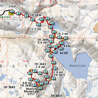
The trail head for this hike is located just
off OR22 at Marion Forks. It is well marked.
Turn east off OR22 and drive about 5 miles to the end of
the FR #2255 to a well marked trail head for Forest TR #3436.
The trail head elevation is about 3360' and Marion Lake is
about 4130', so the three mile hike into the lake is gentle.
The trail starts out in a logged area with significant under
growth and young trees. But after about a half mile, you
will enter the Mt. Jefferson Wilderness Area, and the growth
becomes much more mature with little evidence of human activity,
other than the trail on which you are hiking.
The trail begins to get steeper as you climb the next
mile to the edge of Lake Ann. Then it continues to
climb a bit for the next half mile or so, at which
point you will come to a major junction. At this point
you can go either way. The map above shows you the
two options.
Whether you go clock-wise or counter-close-wise, you
will end up at the bridge that crosses Marion Creek.
The bridge is very new, as the previous bridge was
destroyed by the forces of nature.
If you decide to climb Marion Mountain, you will want to
cross this bridge and begin your ascent by following
TR #3422. It is now that you will begin to walk through
several severely burned areas of the wilderness.
After about another mile of a gentle climb,
you will come to the junction of TR #3443. Bear right
and follow this trail to the west as you begin a bit
steeper ascent over the north flank of Marion Mountain.
However, soon the trail levels off a bit and you are afforded
opportunities to see Mt. Jefferson to the north and
Three Fingered Jack behind you and to the southeast.
This section of the trail runs through the severely
burned area of the wilderness, and you will be viewing
the surrounding peaks through standing dead timber.
It is during this part of the hike where you will most
likely encounter a lot of fallen debris.
After another mile, you will come to the junction of
TR #3435, which you will want to follow to the summit
of Marion Mountain. Again, the trail gets a bit steep,
but it is less than a mile to the top.
The only negative thing about climbing Marion Mountain
is the view of the thousands of acres of burned timber
below you. So sad. Sadder yet, because it was human
caused. Nevertheless, the reward of the incredible vistas
outweighs the disturbing devastation. Enjoy!
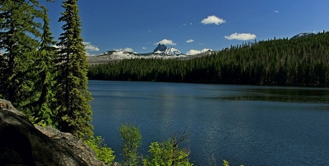
Marion Lake with 3 Fingered Jack
|
How to get there:
From the junction of Forest Road 46 and Oregon state highway 22 at the west end of the community of Detriot Lake,
travel east on Hwy 22 for approximately 16.3 miles to the junction of Hwy 22 and Forest Road 2255 on your left.
This junction is referred to as Marion Forks. Turn onto FR 2255 and follow it literally to the end, where you
will find the trail head to Marion Lake.
|
|
|
A Virtual Hike of the Mount Jefferson Wilderness Area


|
|
