

|
THE FOLLOWING MAP IS NOT TO BE USED FOR NAVIGATIONAL PURPOSES.
|
Length: 10 mile RT
Elevation Change: 1300' cumulative elevation gain
Season: Summer thru Fall
Difficulty: Challenging
Permit: NWF Pass Not Required
GPS:
Latitude: 44.5566
Longitude: -121.9324
Features:
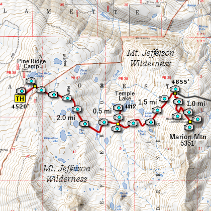
The trailhead for this hike is located just
a short distance south of the entrance to the
Camp Pioneer summer camp for youth.
This hike begins in an obvious parking area,
designated as the trail head for the Pine Ridge Trail #3443.
The trail takes you northeast from the parking area and
in about a half mile connects to the trail used by the
summer camp. You are to bear right, and head east.
The trail begins a gentle descent as you will soon cross
a small stream then climb over a ridge before descending
a couple hundred feet. The trail then levels off as you
come to the junction to Trail #3444, which you can take
to visit Temple Lake.
It is about a half mile to the lake, but you will loose
a couple hundred feet in elevation to reach its shore.
The side trip is very rewarding, especially on days when
you can see Mt. Jefferson trying to peek over the trees
at the north end of the lake.
Obviously, you have to regain the lost elevation you
experienced in reaching the lake as you make your way
back to the junction to Trail #3443. Bear left, or east,
and continue your trek toward Marion Mountain.
Soon you will walk through an area that was burned back
in 2003 by a devastating forest fire. You will see alot
more damage from that fire when you reach the summit of
Marion Mountain. Anyway, continue east for another mile
and a half and you will come to the junction of Trail #3435,
which is the trail you will take to the summit of Marion
Mountain.
You will climb nearly 500 feet in the next mile as you
work your way to the top of this mountain. Even before
you reach the actual summit, you will have several view
points along the way. And when you reach the top of
Marion Mountain you are treated to spectacular views of
Mt. Jefferson, Marion Lake, and Three Fingered Jack.
This hike is a real treat and so worth the effort to get
there! Enjoy.
A panoview from Marion Mountain
|
How to get there:
From the junction of Forest Road 46 and Oregon state highway 22 at the west end of the
community of Detroit, travel east on Hwy 22 about 20 miles to the junction of forest
road 2261 which will be on your left. Turn left onto FR 2261 and follow it for about
5 miles and you will come to a youth camp referred to as Camp Pioneer. Don't turn left
into the camp, but continue on for a few hundred feet to the obvious parking area for
the trail head for this hike.
|
|
|
A Virtual Hike of the Mount Jefferson Wilderness Area


|
|

