|
THE FOLLOWING MAP IS NOT TO BE USED FOR NAVIGATIONAL PURPOSES.
|
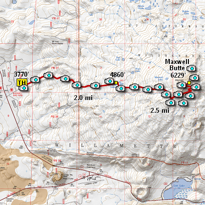
Length: 10 mile RT
Elevation Change: 2600' cumulative elevation gain
Season: Summer thru Fall
Difficulty: Difficult
Permit: NWF Pass NOT Required
GPS:
Latitude: 44.4636
Longitude: -121.9324
Features:
The trail head for this hike is located just
off US20 at the far east end of the Maxwell
Butte SnoPark area. It is well marked.
This is outstanding hike with a great deal of
variety. The trail starts out gently while
passing through fairly dense forested areas.
However, it does get gradually steeper and often
there is winter blow down that you have to climb
over or around.
At about 1.25 miles, you will come to a fallen sign
indicating that you are entering the Mt. Jefferson
Wilderness Area. It is another 3/4 of a mile to
the main junction that offers you the choice to climb
Maxwell Butte. Bear right at the sign and continue east.
Just as you leave this junction, you will catch glimpses
of a single lake (or pond) which has the unlikely name
of Twin Lakes. I must have missed the twin. Anyway,
a very short stroll to the lake edge gives you more
variety to add to this adventure. You can see Maxwell
Butte from the lake shore and to your east.
As you make your way back to the main trail and head
east toward Maxwell Butte, the trail actually gets better.
I have concluded this is due to the higher altitude and
less available timber to succumb to the winter elements.
But whatever the reason, the trail really becomes delightful
but it also gets steeper. Yet as it gains elevation it
also provides you with your first real vistas of the
surrounding Cascade volcanos and mountains.
After another couple of miles, the trail really begins
its ascent of the butte and is quite steep, yet well
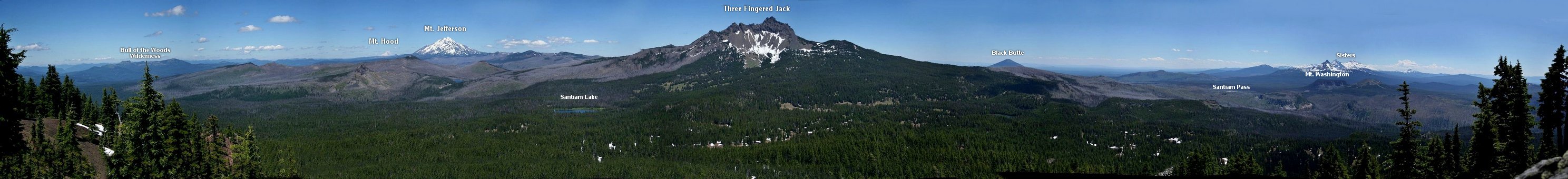
switch backed all the way to the summit. The top of
Maxwell Butte offers you fantastic, breath-taking vistas
that you will most likely remember forever!
|
How to get there:
From the junction of Forest Road 46 and Oregon state highway 22 at the west end of the
community of Detroit, travel east on Hwy 22 about 28.8 miles to the Maxwell Snow Park
which will be on your left. Turn into the snowpark area and follow the forest service
road to the east for about a half mile and you will find the trail head to this hike.
|
|
|
A Virtual Hike of the Mount Jefferson Wilderness Area


|
|