|
Features:
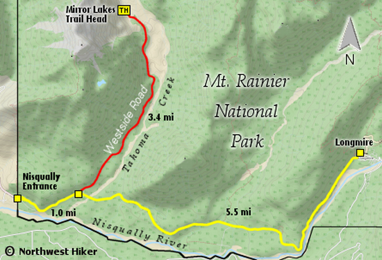
This is a world class hike that begins on a gated
road that used to take travelers deep into the
Mt. Rainier National Park. Recent flood damage
closed the road to all but Park personnel.
Even though you hike the first 1.2 miles on the
old roadbed, this hike is so worth it. Also,
because of the flood damage to the trail itself,
the Park Service does not maintain the trail.
However, others do, so the trail is very hikeable.
 Just after you actually begin hiking on the trail,
it wanders out onto the flood plain of the Tahoma
River. This part of the trail can be very difficult
to follow in that seasonal flooding can remove any
evidence of just where the trail is suppose to be.
Just after you actually begin hiking on the trail,
it wanders out onto the flood plain of the Tahoma
River. This part of the trail can be very difficult
to follow in that seasonal flooding can remove any
evidence of just where the trail is suppose to be.
Those good folks who are choosing to keep this trail
alive and viable, do a great job of marking the path
as early in the season as possible, so you should not
have much difficulty in following the trail.
For the first 2.1 miles of the actual trail, it follows
along the north side of the river until it connects with
the Wonderland Trail. Be aware, however, that there are
two significant challenges along this stretch of the trail.
In two places the river has cut so deep into the riverbank
that the trail has collapsed completely, and the only way
around these areas is to follow the user trails up the
extremely steep hillside, over the washout area, and back
down very steep inclines to the original trail.
 After you come to the junction with the Wonderland trail,
just bear right and a hundred feet you will come to one of
the most amazing bridges you may have ever seen. A relatively
new suspension bridge offers you a way across the canyon of
the Tahoma River. The bridge is 206 feet long and you will
be suspended about a hundred feet above the river.
After you come to the junction with the Wonderland trail,
just bear right and a hundred feet you will come to one of
the most amazing bridges you may have ever seen. A relatively
new suspension bridge offers you a way across the canyon of
the Tahoma River. The bridge is 206 feet long and you will
be suspended about a hundred feet above the river.
It is after you cross the bridge that the trail begins to climb.
And it climbs very steeply for next 1.2 miles, and you will gain
over a 1000 feet in elevation. It is as you near the ridgeline
that you begin to get your best views of Mt. Rainier.
When you reach the junction of the Wonderland trail and the
trail to the Mirror Lakes area, I recommend that you continue
uphill on the Wonderland for about a half mile
where you will come to an amazing log cabin. It is used by
the Park Service in the summer and is referred to as
Indian Henry's Patrol Cabin. Just to the right of the
cabin is a fine little pond worth the short walk.
Then after investigating the cabin area, return to the junction
of the Wonderland trail and the Mirror Lakes trail, and head
on over to the lakes. The lakes in themselves are not spectacular,
however the views of Mt. Rainier are. If you continue on the
trail, which leads to Pyramid Peak, you will come to your best
views of the mountain.
This hike would be best enjoyed during the wildflower bloom,
which is in late July through mid-August. However,
this hike is not for the faint of heart. It is long.
Take plenty of water, and rest often.

Wonderland Trail crosses Tahoma Creek
|