|
Features:
This is a extremely popular hike in the Mt. Rainier National Park because of its
easy access and its tremendous reward. Obviously, you can hike this trail
either clockwise or counter-clockwise. Either way, will provide an outstanding
adventure.
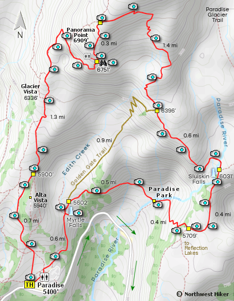
I present this description as hiking clockwise beginning on the Skyline
Trail close to the visitor center at Paradise. The first 7/10ths of the trail is
paved and rather steep. There are a number of intersections along the
way, so be sure to continue on the Skyline Trail.
 In season the wildflowers here are extraordinary. However, there are years when
the winter snow doesn't melt away until August. The best floral displays occur
just after the snow melt, especially for the glacier lilies, which typically
bloom 2 weeks after the snow melt.
In season the wildflowers here are extraordinary. However, there are years when
the winter snow doesn't melt away until August. The best floral displays occur
just after the snow melt, especially for the glacier lilies, which typically
bloom 2 weeks after the snow melt.
This Skyline Trail that leads to Panorama Point provides world class views of Mt. Rainier and the
surrounding mountain ranges to the south. Deer and bear are often seen from this trail and are
no cause for alarm if you remain on the trail and do not approach them.
 About a mile and a half into the climb towards Panorama Point, a spectacular waterfall
can be seen across the Nisqually Glacier canyon to the west.
About a mile and a half into the climb towards Panorama Point, a spectacular waterfall
can be seen across the Nisqually Glacier canyon to the west.
Within a mile of hiking toward Panorama Point, you will be above the tree line and surrounded
by breath taking views in every direction. The furry little marmot is a frequent presence
along the trail.
Approximately 2 miles into the hike, you will come to an outstanding
viewing area about a half mile from and below Panorama Point. Just
a short distance from this viewpoint is a restroom facility. it is
just a short climb from there to the place where you can
access Panorama Point. Another quarter mile and you will come
to a junction where you can select the trail to the east
to complete the loop portion of this hike.
 The next couple of miles the trail drops steeply downhill and away from Mt. Rainier,
so be sure to stop frequently and look back at the magnificent views.
About a mile and a half you will come to a junction to a trail that leads directly
downhill and will bypass the displayed route that circles to the east.
This downhill option is referred to as the Golden Gate trail.
The next couple of miles the trail drops steeply downhill and away from Mt. Rainier,
so be sure to stop frequently and look back at the magnificent views.
About a mile and a half you will come to a junction to a trail that leads directly
downhill and will bypass the displayed route that circles to the east.
This downhill option is referred to as the Golden Gate trail.
I encourage you to not take the short cut unless time is an issue.
The trail continues to descend to the east and drops down into a
shallow valley and crosses the Paradise River on a sturdy bridge.
After a brief climb out of this valley, the trail continues to
descent to the junction where the trail descending to the
Reflection Lakes is available.
 To return to the Paradise parking area, you will want to continue
straight ahead and descent into the Paradise River valley. This
descent offers incredible views of Mt. Rainier and in season,
extraordinary floral displays. In this valley, you will cross
the river on a sturdy bridge just before climbing back up out
of the valley and meeting up with the Golden Gate trail.
To return to the Paradise parking area, you will want to continue
straight ahead and descent into the Paradise River valley. This
descent offers incredible views of Mt. Rainier and in season,
extraordinary floral displays. In this valley, you will cross
the river on a sturdy bridge just before climbing back up out
of the valley and meeting up with the Golden Gate trail.
Continuing on toward the parking area will take you across Edith
Creek on another sturdy bridge. After crossing the creek, you
can drop down a short distance to a viewina area for a beautiful
little waterfall on Edith Creek.
Returing to the main trail, just continue downhill and you will
arrive at the parking area for Paradise.

Mt. Rainier from the Skyline Trail
to Panorama Point
|