Length: 6.8 mile one way
Elevation Change: 2172' gain
Season: Summer thru Fall
Difficulty: Difficult
Permit: NW Forest Pass Required
Latitude: 48.7024
Longitude: -119.9543
Features:
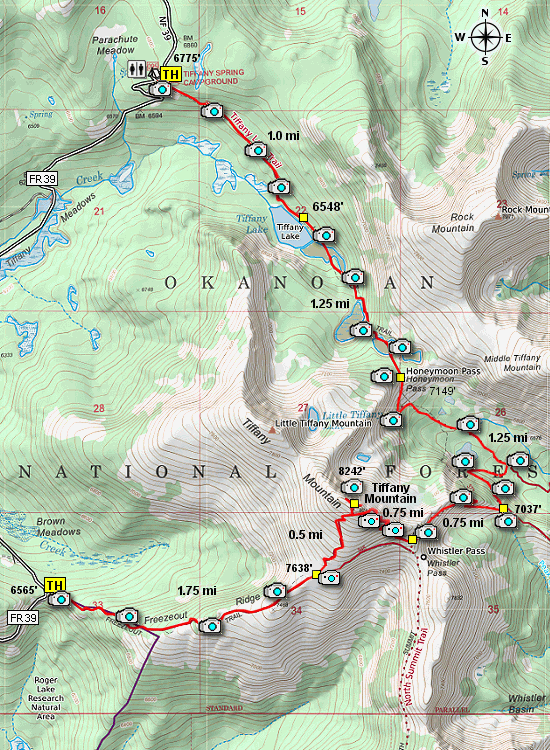
The trailhead for this hike is located just
across the road from Tiffany Springs campground. It is well marked.
For the first mile the trail descends through a recently burned forest to Tiffany Lake.
The trail follows along the Northeast side of the lake and offers several outstanding vistas including Tiffany Mountain.
A the east end of the lake the trail climbs steadily to Honeymoon Pass,
which is about 2 miles from the trailhead.
In season this part of the trail offers outstanding floral displays.
If you are quiet and alert, you are likely to see both deer and elk.
From Honeymoon Pass you are treated with the best view of the north face of Tiffany Mountain which
even in the last summer has snow hidden in the deep crags.
Now the trail begins to descends for about a half a mile through burnt forest and open meadows.
After a half mile descent from Honeymoon Pass, the trail makes a sharp right turn
and is fairly difficult to follow. Then the trail makes a sharp left turn and begins
a very steep half-mile climb to the ridge line.
From the ridge line, you can see Whistler Pass to which the trail takes you and where you will begin your climb
up Tiffany Mountain. The hike along this stretch of the trail is great because of the views and the
abundant wildflowers (in season). There are a couple of switchbacks along the way, but all in all this
part of the trail is great.
Once you reach the pass, the trail levels off as it makes its way along the southern flank of Tiffany Mountain.
The trail to the summit is a users trail and marked by a large rock cairn. The trail up to the summit is
easy to follow and offers incredible views, especially to the north where below you is the trail you just took
to get there.
Upon reaching the summit, the trail drops down the southwest side of the mountain and reconnects with the main trail
that you left earlier to hike to the summit. Continue downhill all the way to the parking area, which concludes
this shuttle hike.

Looking north towards Canada from the summit of Tiffany Mtn
|