Length: 8.75 miles round trip
Elevation Change: 2454' cumulative elevation gain
Season: Summer thru Fall
Difficulty: Difficult
Permit: NW Forest Pass Required
Latitude: 48.4586
Longitude: -120.5673
Features:
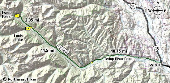
The trailhead for this hike is located at the end
of Forest Road 4440 which is the parking area for
a small campground. This hike follows FS Trail 432.
About 500' before this parking area, there is a
trail sign and a smaller parking area where you
can access the trail without parking in the camp
area, and it is a more gentle approach to the trail.
The trail follows the Twisp River for the first two
miles, then crosses the North Fork of the Twisp River on a single large log.
After crossing the river, the trail begins to climb
in earnest. The good news is, that the scenery
improves dramatically.
About a half mile from the crossing, the trail takes
you along a wide open cliffy area to your left. It
well worth the detour out onto this open area where
you get your first breath-taking views of the local
mountains. Also, this is a great place to take a break.
As you continue on your way to Twisp Pass the trail
now becomes more exposed and narrow in places. Just
use common sense and caution and you should not experience
any real danger. The views just keep getting better
and better.
There are a couple of really steep and eroded areas
and a major switchback just before reaching the pass.
When you arrive at Twisp Pass you will be greeted by
a sign announcing your entry into the North Cascades
National Park. However, this hike and description
ends at the pass.
As you look around, you will see Dagger Lake below
you and accessible via this same trail, but well
within the National Park. Also, to the west you
will have a great view of some of the taller peaks
of the North Cascades, such as Goode Mountain which
is over 9200 feet in elevation.
This hike is not for faint hearted. It is long.
Take plenty of water, and rest often.
 and Twisp Mtn from the Twisp Pass trail (right)")
Looking west towards Hock Mtn (center)
and Twisp Mtn from the Twisp Pass trail (right)
|