Hike 05
The Columbia River Gorge National Scenic Area
Bridal Veil Overlook Hike
Search West Hikes West Central East Central East Hikes
Home Page
Main Map


Click to view product details

THE FOLLOWING MAP IS NOT TO BE USED FOR NAVIGATIONAL PURPOSES. Bridal Veil Overlook Loop hike map
Map of Bridal Veil Overlook Loop hike

Length: 0.75 mile loop
Elevation Change: none
Season: Year Round

Difficulty:    Easy
Permit: Not Required
GPS:   N45 33.214 W122 10.978
Features:


NEW!
 Click for PDF Topo Map of this Hike 

This hike follows a loop trail that takes the visitor to a number of scenic overlooks of the Columbia River.  The path is paved and is nearly level. In the spring the Camas Root with its blue flower (pictured below) covers this area with exceptional beauty.


Camas Root Wildflowers
This area is famous for the spring display of the Camas Root wildflower

How to get there:

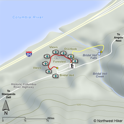
From the west, take I-84 to Exit #28/Bridal Veil. Turn south onto the Historic Columbia River Highway and drive 0.75 miles to Bridal Veil Falls State Park on the left/north side of the road. Coming from the east on I-84, take exit 35 (Ainsworth Park) and drive 8.3 miles west on the Historic Highway to reach Bridal Veil Falls State Park.


Hike Difficulty Calculator

Calorie Burn Calculator

The 10 Essentials
Bear Encounters

Cougar Encounters

River Crossing Safety
A Virtual Hike of the Columbia River Gorge National Scenic Area


Click to View Instructions