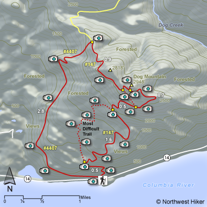
Length: 7 mile loop, give or take
Elevation Change: 2800' gain
Season: Spring thru Fall with occasional winter opportunities
Difficulty: Difficult due to steepness of trail
Permit: NW Forest Pass Required Normally.
Special permit on weekend in peak season.
GPS: N45 41.958, W121 42.492
Latitude: 45.6993
Longitude: -121.7082
Features:
An excellent hike up a fairly steep mostly forested mountain to the
open vistas of the top. In season (late May thru June) the
floral displays are among the best.
The trail head parking lot is
very large for a hiking area, which attests to the popularity of
this hike. There are three basic ways to climb Dog Mtn:
- #1 - the western route - longer - gentler - very scenic
- #2 - the central route - shortest - steepest - forest
- #3 - the eastern route - moderate - most view at top
Whatever route you choose, and whatever season you choose, you will find this a spectacular hike for sure.
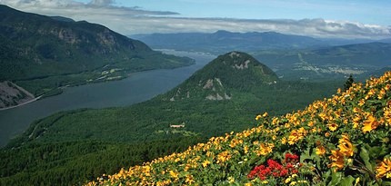 Looking west toward Wind Mountain from the summit
of Dog Mountain in spring
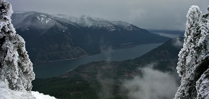 Looking west from the summit of Dog Mountain in winter
|
How to get there:
From Portland, travel east on Interstate Hwy 84 to Exit 44 to Cascade Locks.
Exit the freeway and cross over the Columbia River into Washington
via the Bridge of the Gods. Then turn right, or east, and head
east through Stevenson, Washington to the intersection of the Wind
River Highway to Carson, Washington. However, just continue east
on SR14 for another 6.2 miles and you will come to the large parking
area and trailheads for both the Dog Mountain and Augspurger Mountain hikes.
From Vancouver, WA travel east on SR14 through Stevenson, Washington to the
intersection of the Wind River Highway to Carson, Washington. However, just
continue east on SR14 for another 6.2 miles and you will come to the large parking
area and trailheads for both the Dog Mountain and Augspurger Mountain hikes.
From either direction, due to overcrowding at the Dog Mountain trailhead in peak season, we highly recommend for safety that
you consider using the Skamania County Gorge West End Transit bus .
The price is low and the convenience is high.
|