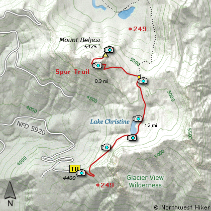
Length: 3 Miles round trip
Elevation Change: 1075 Elevation gain
Season: Summer thru Fall
Difficulty: Challenging
Permit: NW Forest Pass NOT Required
Features:
This short but very steep hike begins at the end of Forest Road 5920.
The trail begins an extremely steep climb immediately. However, in
a short distance it begins to become more reasonable as it switchbacks
up the very steep terrain toward Lake Christine.
In about a mile you break over a saddle and come upon Lake Christine.
This a beautiful little lake nestled between opposing peaks. The
trail goes around the south side of the lake in what can be a very
marshy area.
On the east side of the lake, the trail heads northeast on its way to
Goat Lake. About a half mile later, you will come to a sign with the
word TRAIL on it. The trail to Goat Lake bears right. You need to
bear left and follow a user trail up very steep terrain. Soon the
trail breaks out into the open and as you reach the summit of
Mount Beljica, you are greeted with outstanding vistas of Mt Rainier,
the Goat Rocks, Mt Adams, Mt Hood, and Mt St Helens.
In season there are lots of beautiful floral displays to add to the
enjoyment of this short but challenging hike.
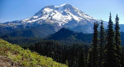
Mt Rainier as seen from Mount Beljica
|