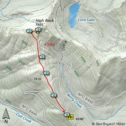
Length: 3.2 Miles round trip
Elevation Change: 1365 Elevation gain
Season: Mid-Summer thru Fall
Difficulty: Challenging
Permit: NW Forest Pass Required
Features:
The hike to the top of High Rock is an unique experience.
The summit is often referred to as High Rock Lookout, because
of the functional fire lookout still perched on top.
The trail is very steep, but well defined until you reach
the top. The hike begins at Forest Road 8440 and immediately
begins a steep climb.
There are a few vistas at the very beginning of the hike,
but most of the views are at the end when you reach the top
of High Rock. For the most part the trail climbs through
forested areas. Interestingly, this hike has a couple of
wooden benches for a hiker to rest on while hiking up the
trail.
In season the flowers, especially Beargrass, are very plentiful.
Avalanche Lilies, Lupine, and Paintbrush are abundant in season.
Mosquitos are also abundant in season, which seems to last from
the beginning of January to the end of December (hee hee).
This hike is very popular and frequently hiked. Nevertheless,
it is truly worth the effort. If you can, hike the trail
during the week, and you will have a lot less company. Also,
there is a motorize vehicle season on this hike, so check
with the local forest service to learn of the dates.
High Point is only one of 3 peaks in the Gifford Pinchot NF
that has a lookout on top of it. When you approach the summit,
you must use extreme care to stay away from the cliff located
on the north side of the mountain. The trail is pretty much
obscure at this point, and cables have been installed in the
rock to give climbers a secure hold on the mountain.
The north side of the mountain has a 600 foot cliff, with another
1000 feet to bounce off on your way down, so be extremely
careful. This is no place for those afraid of heights, or
for those with immature judgement. Having said that, I must
also say that the views up there are just awesome.
Of course Mt Rainier is the main attraction. But there is also
the Sawtooth Range itself, then to the northeast, the Tatoosh
Range, and to the east-southeast are the Goat Rocks, followed to
the southeast by Mt Adams, and to the south Mt Hood, and last
but not least, to the south-southwest is Mt St Helens.
This is an arial view without the airplane.
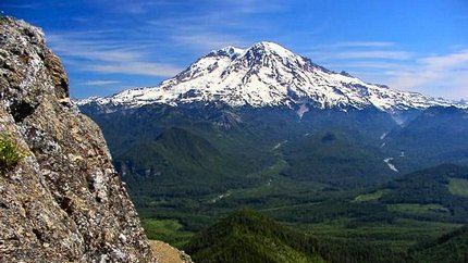
Mt Rainier from the summit of High Rock
|
How to get there:
NEW!
Click for PDF Directions Map of this Hike
From Puyallup, WA
From the junction of SR512 and SR161 in Puyallup to the junction of SR161 and SR7 in Elbe is
about 36 miles. Then traveling east on SR161 it is about 8 miles to Ashford.
From Morton, WA
Follow SR7 north out of Morton for about 16 miles to the junction of SR161 in Elbe. Turn right
onto SR161 and travel about 8 miles east to Ashford.
From Ashford travel east on highway 706 for about 2.3 miles. Turn right (south) onto Kernahan Rd East
which will become Skate Creek Road. This road is also designated as Forest Road 52.
Follow FR52 for about 4.7 miles and you will come to the junction with Forest Road 84. Turn right (south)
onto FR84 and follow it for about 1.4 miles until you come to Forest Road 8410. Continue on FR84 for
another 2.8 miles and you will come to Forest Road 8420. Continue on FR84 for another 2.5 miles and you
will come to the junction of Forest Road 8440. Bear right onto FR8440 and follow it for another 2.7 miles,
where you will come to a sharp right turn at a saddle on a ridge. This is where the trailhead for this hike is located.
|