

|
THE FOLLOWING MAP IS NOT TO BE USED FOR NAVIGATIONAL PURPOSES.
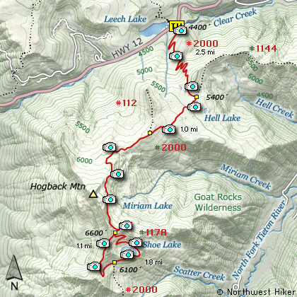
Map of the Shoe Lake, PCT, White Pass, Goat Rocks Wilderness
|
Length: 15.5 Miles round trip
Elevation Change: 2900' Elevation gain /700' loss
Season: Mid-Summer thru Fall
Difficulty: Difficult
Permit: NW Forest Pass Required
Features:
This is one of the most popular hikes in the Goat Mtn Wilderness.
Having said that, only once have I met more than a couple of people
while hiking to this lake. The trail head is along US Hwy 12 just
a bit east of White Pass. This hike is almost entirely on the
Pacific Crest Trail #2000.
The trail begins to climb rather steeply right off the bat. The
first 2 miles are uphill and in dense forest. At about 2.5 miles
you will come to the junction to Trail #1144 to Twin Peaks to the
east. Also, at this point the trail begins to wander in and out
of the dense forest and offers more meadow views.
In season this hike is a walk through wildflowers. Almost from
the beginning and certainly at the end, wildflowers of many types
are replete. The trail skirts the White Pass Ski Area but you
never actually see any of it.
At about 5 miles the trail enters a very open area. At about 5800'
elevation the trees are small and further apart. The trail now
follows along the east side of Hogback Mountain and is almost
entirely out in the open.
At about 6.5 miles the trail crosses over a saddle and you get your
first views of the Goat Rocks in the near distance and Shoe Lake
below you. It is a short walk to the junction of the trail that
will take you to the east around Shoe Lake and eventually back to
the Pacific Crest Trail.
The trail drops about 700' elevation descending to Shoe Lake. In
season this area around the lake is an absolute floral garden. And
the views never quit. It is no wonder why this hike is so popular.
Following the trail around the east side of the lake brings you
to the best views of the lake.
After enjoying this gem of nature, continue on the trail until you
meet up with the PCT #2000. Bear right and climb back up the 700'
you lost to the saddle about Shoe Lake. Then follow the trail back
to its trail head.
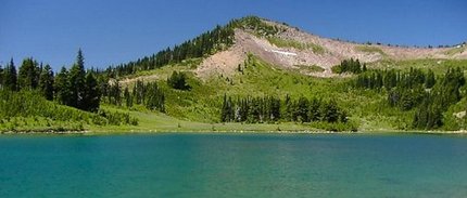
Shoe Lake
|
How to get there:
NEW!
Click for PDF Directions Map of this Hike
From I-5 junction with US Hwy 12
Travel east on US Hwy 12 for about 64 miles to Packwood.
From Packwood travel east on US Hwy 12 for about 21 miles, and just after passing
White Pass and beginning to drive downhill, you will come the Pacific Crest Trail.
Bear right into the parking area for the trail, which is the trailhead for this hike.
|
|
|
A Virtual Hike of the Goat Rocks Wilderness Area


|
|


