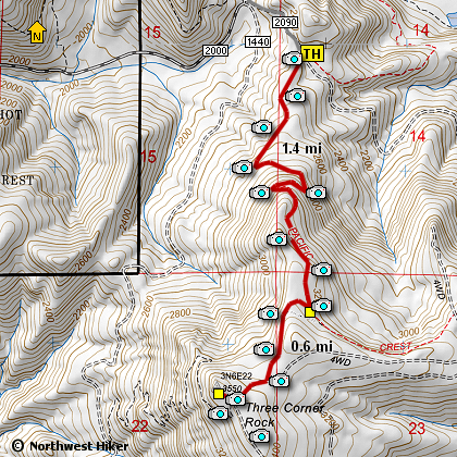
Length: 4 mi RT
Elevation Change: 800' gain
Season: Spring thru Fall
Difficulty: Moderate
Permit: Discover Pass Required
GPS: N45 44.958, W122 2.604
Latitude: 45.7493
Longitude: -122.0434
Features:
This is a spectacular little gem of a hike for those of all ages. And the hike
is pet friendly.
There are several ways to hike to Three Corner Rock, and this option is likely
the most gentle and brief. The trail to Three Corner Rock is the Pacific Crest
Trail, which is well marked at the parking area. The PCT crosses the road at
the parking area, so be sure to head south or you might end up in Canada!
The trail climbs gently through rather dense new growth timber consisting
mostly of douglas fir and hemlock. In season the trail is lined with a large
variety of beautiful wildflowers, which is one of the main draws to this hike.
As you near the summit, the trail follows a service road for a short steep
ascent to the base of Three Corner Rock. On a clear day you will be able
to view Cascade mountain peaks from Mt. Jefferson to the south to Mt. Rainier
to the north. Mt. St. Helens is the closest, and Mt. Adams is prominent to
the east.
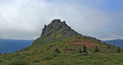
View of Three Corner Rock
|
How to get there:
From the Washington side of the Bridge of the Gods, drive SR 14 east to milepost 43.
Turn left on Rock Creek Drive (signed for Skamania Lodge
and Columbia Gorge Interpretive Center). At 0.3 mile, just past the entrance drive for Skamania Lodge,
turn left on Foster Creek Road (which becomes Ryan Allen Road. At 0.9 mile, turn left on Red Bluff Road
for 0.3 mile, then continue on gravel DNR Road CG 2000. Take this winding, uphill road along Rock Creek.
At about 8.5 miles, the PCT crosses this road. For this hike however, continue going uphill on CG 2000 to
where it tops out at Rock Creek Pass. At the past CG 2000 curves to the right, and CG 1440 heads abruptly
downhill and mostly straight ahead, but to reach the PCT trailhead,go straight ahead on Road CG 2090
for 0.3 mile to the PCT crossing.
|