

|
THE FOLLOWING MAP IS NOT TO BE USED FOR NAVIGATIONAL PURPOSES.
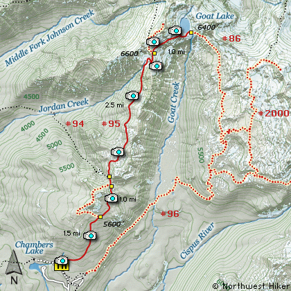
Map of the Goat Lake, Goat Rocks Wilderness Hike
|
Length: 11 Miles round trip
Elevation Change: 2000' Elevation gain / 400' loss
Season: Mid-Summer thru Fall
Difficulty: Challenging
Permit: NW Forest Pass Required
Beargrass Bloom: 2018
GPS: N46 28.008, W121 31.662
Latitude: 46.4668
Longitude: -121.5277
Features:
This hike to Goat Lake via Goat Ridge follows Trail #95
from the Trail Head on Forest Road #2150.040 near what
is referred to as the Berry Patch. The trail head is
not the same as the trail head to Snowgrass Flats.
Follow the signs carefully when you park.
The first 4 miles of this hike is mostly in
forested areas with limited views.
The trail begins a very steep climb immediately, and
continues to do so for the first couple miles. Actually,
you are given the opportunity to do a loop around the
Goat Ridge Lookout Trail, but on this hike, I'd
recommend just getting to Goat Lake and back, so
stay to the right as you pass Trail #95A. Eventually,
you will meet the same trail again at the other end
of it. Just keep on Trail #95 heading to Goat Lake.
At about 2.5 miles you will past the Jordan Creek
Trail #94. Keep straight ahead, climbing again and
crossing a small stream, which could be a problem
in early summer. All along this trail you will be
treated to wildflower displays. The closer you get
to Goat Lake the better the displays.
At about 4.5 miles you will climb up into a really neat
circ. You will be out in the open from now on.
Switchbacking your way up the east side of this
area will bring you to a saddle between the two valleys
and to the Lily Lake Trail #86. Again, bear right
and continue to Goat Lake.
At about 6 miles you will come upon Goat Lake.
The approach to the lake is outstanding, in that
you approach from above the lake, looking down.
Don't forget to look up and examine the surrounding
hillsides for the ever-present mountain goats.
And don't be surprised if the lake is frozen. It
usually doesn't thaw until mid-August.
This is a long rough, yet rewarding hike.
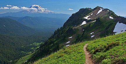
Mt Adams as seen from Goat Ridge
|
How to get there:
NEW!
Click for PDF Directions Map of this Hike
From I-5 junction with US Hwy 12
Travel east on US Hwy 12 for about 48 miles to Randle.
From Randle travel east on US Hwy 12 for about 13.3 miles to the junction with
Forest Road 21. Turn right (south) onto FR21 and follow it uphill for about 5 miles.
At this point you will see Forest Road 2110 on your left, which is the road to the
Glacier Lake trailhead, but you continue straight ahead on FR21. In another 8.1 miles
you will come to the junction of Forest Road 2150. Bear left onto FR2150 and follow it
about 3 miles and you will pass the junction on your left which leads to the
Chamber Lake campground. Continue ahead just a short distance, on what is now called
FR 040 to what is referred to as the Berry Patch trailhead. This hike and many more begin here.
|
|
|
A Virtual Hike of the Goat Rocks Wilderness Area


|
|


