Length: 4.6 Miles round trip
Elevation Change: 1480' Elevation gain
Season: Mid-Summer thru Fall
Difficulty: Difficult
Permit: NW Forest Pass Required
Features:
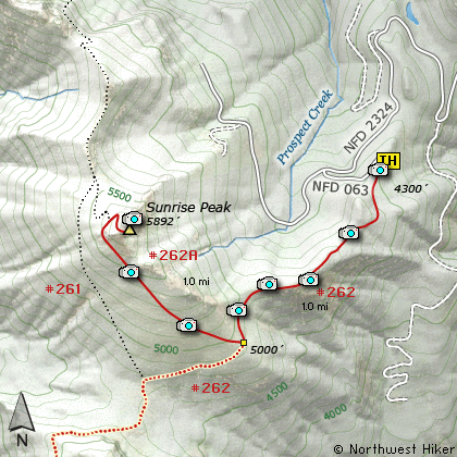
This hike begins off Forest Road 2324.063 which is
off Forest Road 23. This approach to Sunrise Peak
allows you to drive up much of the elevation.
This hike is short but very very steep. Even
though your first steps are downhill, don't let that
fool you. The rest of the trail is straight UP!
The hike begins in a very dense forest, but after
about a half mile you break out into the open
where you will remain for the balance of the hike.
Wildflowers are extremely abundant in season and
add a great deal of enjoyment to this hike.
At about 1 mile you come to a junction that allows
you to take Trail #261A to the top. Bear to the
right and begin one of the steepest climbs you will
encounter. With each step the views improve. The
wildflowers help make all this worth the effort.
In another half mile you will come to another
junction to a different approach to the peak.
Bear right and continue on to the top. The
last 1/4 mile has a very steep grade with plenty
of switchbacks to make it tolerable.
To reach the very top you must climb up steep
rock with a metal rail in place to help you.
When on top you are treated to more beauty than
the eye can behold. Mt Rainier, Mt Adams, and
of course Mt St Helens. Its sooooo worth it!
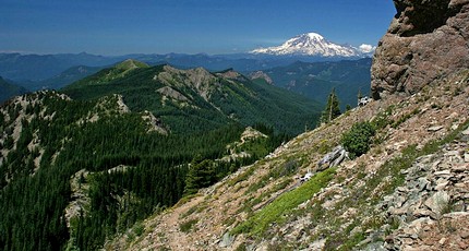
Mt Rainier as seen from the Sunrise Peak trail
|
How to get there:
NEW!
Click for PDF Directions Map of this Hike
From I-5 junction with US Hwy 12
Travel east on US Hwy 12 for about 48 miles to Randle.
From Randle, travel south on State Road 131, crossing the Cowlitz River and in a mile
you will come to Cispus Road on your left. Bear left and follow Cispus Road, which become
Forest Road 23, for another 5.2 miles and you will pass Forest Road 55 on your left.
Continue on FR23 for another mile and you will pass Forest Road 083 on your left, which
is the road to Layser Cave. But you keep straight ahead on FR23 for another 1.9 miles.
You will then come to the junction of Forest Road 28. Just continue on FR23 for another
6.7 miles and you will come to Forest Road 171 on your left which takes you to the Blue
Lake trailhead. But you continue south on SR23 for another 2.8 miles. Then you will
come to the junction of Forest Road 21. Bear right and continue on FR23 as you cross
the Cispus River. Drive another 4.5 miles to the junction of Forest Road 2324. Bear right
onto FR2324 and follow this rocky and challenging road uphill for 5.3 miles. Then you
will see Forest Road 063 on your left. Make a very sharp left turn onto FR063 and follow
this short road uphill to the parking area for this and other hikes in the area.
|