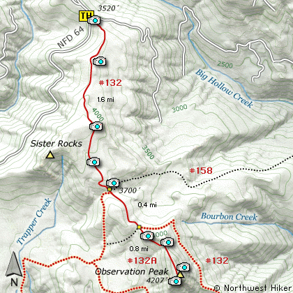
Length: 5.6 Miles round trip
Elevation Change: 900' Cumulative Elevation gain
Season: Summer thru Fall
Difficulty: Moderate
Permit: NW Forest Pass Required
Features:
This hike begins off Forest Road #58. The
trail head is well marked. The trail begins
a moderate climb and it makes its way through
fairly dense forest. There are only a couple
of viewpoints along the way.
At about a mile the trail summits out at
a rocky area where you can get great views of
Mt Adams to the east and Mt Rainier to the north.
The trail then descends following a small stream
part of the way. After a few switchbacks
you will come to the junction of Trail #158.
Keep on straight ahead. In only a few yards you
will come to another junction with Trail #192.
Again, keep on straight ahead.
At about 2 miles you will come to yet another
junction. At this point, bear to the right,
and follow Trail #132A. The trail gets a bit
steep as you work your way up the side of
Observation Peak. There is a fine viewpoint
along the way, but the best views are waiting
for you at the top.
Upon reaching the summit of Observation Peak
you are treated to wonderful views of all the
surrounding terrain, including Mt St Helens,
Mt Rainier, Mt Adams, and the Columbia River
Gorge.
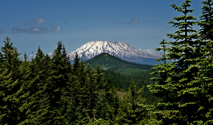
Mt St Helens as seen from the summit of Observation Peak
|
How to get there:
NEW!
Click for PDF Directions Map of this Hike
From Portland, OR
From Portland, travel east on Interstate Hwy 84 to Exit 44 to Cascade Locks.
Exit the freeway and cross over the Columbia River into Washington
via the Bridge of the Gods. Then turn right, or east, and head
east through Stevenson, Washington to the intersection of the Wind
River Highway to Carson, Washington. Bear left onto the Wind River
Highway which will take you through Carson, Washington.
from Vancouver, WA
From Vancouver, WA travel east on SR14 through Stevenson, Washington to the
intersection of the Wind River Highway to Carson, Washington. Bear left onto the
Wind River Highway which will take you through Carson, Washington.
from Carson, WA
Continue north on the Wind River Highway (FR30) for about 8.6 miles to the
little community of Stabler and the junction with Forest Road 43, also called
Hemlock Road. Continue northwest on FR30 for another 5.4 miles and you will
pass a fish hatchery on the left. Continue on another half mile and turn
right at the junction with Forest Road 3065, which continues straight ahead.
After turning right at the junction with FR3065, continue another 2.1 miles
to the junction with Forest Road 64. Bear left onto FR64 and climb steeply
for another 6 miles to the junction with Forest Road 58. Bear left onto FR58
and follow this road for another 2 miles and you will come to the parking
area and trailhead for this hike on your left.
|