Hike 62
The Gifford Pinchot National Forest
Indian Race Track Hike
Search North Goats Central Adams SE Hikes SW Hikes St Helens
Home Page
Main Map


Click to view product details

THE FOLLOWING MAP IS NOT TO BE USED FOR NAVIGATIONAL PURPOSES.
Map of the Indian Race Track, Indian Heaven Wilderness Hike

Length: 1.6 Miles round trip
Elevation Change: 520' Elevation gain
Season: Summer thru Fall
Difficulty:   Moderate
Permit:   NW Forest Pass Required
Features:


NEW!
 Click for PDF Topo Map of this Hike 

Here is a fun little hike loaded with natural beauty as well as native history. The Indian Race Track hike begins off Forest Road 6048 near the summit of Red Mountain just outside of the Indian Heaven Wilderness.

The hike begins on the side of a mountain therefore the trail loses elevation immediately. During the first part of the hike you will be in and out of the forest therefore you get incredible views of the surrounding terrain, including Mt Adams to the northeast.

In about a half mile the trail descends into a heavily forested area and remains that way until you reach the meadow named - Indian Racetrack. It is my understanding that this meadow was used by the native American peoples for get togethers during the summer and fall food gathering months. I have read that this area is referred to as a racetrack because the people could safely race on horseback.


Small pond near the Indian Racetrack in the Indian Heaven Wilderness
Small pond near the Indian Racetrack
How to get there:

NEW!
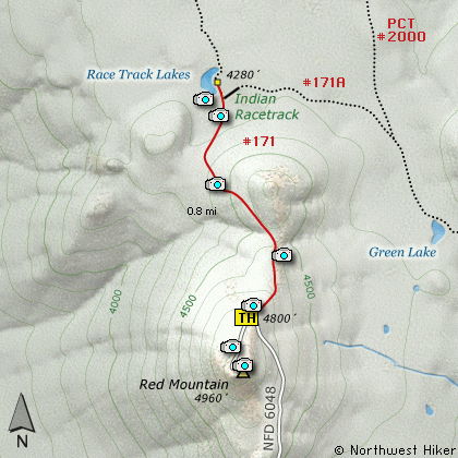
 Click for PDF Directions Map of this Hike 

From Portland, OR
From Portland, travel east on Interstate Hwy 84 to Exit 44 to Cascade Locks. Exit the freeway and cross over the Columbia River into Washington via the Bridge of the Gods. Then turn right, or east, and head east through Stevenson, Washington to the intersection of the Wind River Highway to Carson, Washington. Bear left onto the Wind River Highway which will take you through Carson, Washington.

from Vancouver, WA
From Vancouver, WA travel east on SR14 through Stevenson, Washington to the intersection of the Wind River Highway to Carson, Washington. Bear left onto the Wind River Highway which will take you through Carson, Washington.

from Carson, WA
Continue north on the Wind River Highway for about 5.8 miles to the junction of the Wind River Hwy and the Old State cutoff road east. In just a few hundred feet turn left, north, onto Forest Road 65. In another 4.7 miles you will pass Forest Road 68. Continue north on FR65 for another 6.1 miles and you will come to the intersection of Forest Road 60. Bear right onto FR60 and head east for 1.5 miles to the junction of Forest Road 6048. Bear left onto FR6048 and follow this rough steep road another 2.8 miles to the parking area and trailhead to this hike.


Hike Difficulty Calculator

Calorie Burn Calculator

The 10 Essentials
Bear Encounters

Cougar Encounters

River Crossing Safety
A Virtual Hike in the Gifford Pinchot National Forest


Click to View Instructions