Length: 16.5 Miles round trip
Elevation Change: 1500' Cumulative Elevation gain
Season: Summer thru Fall
Difficulty: Difficult due to the length
Permit: NW Forest Pass Required
Features:
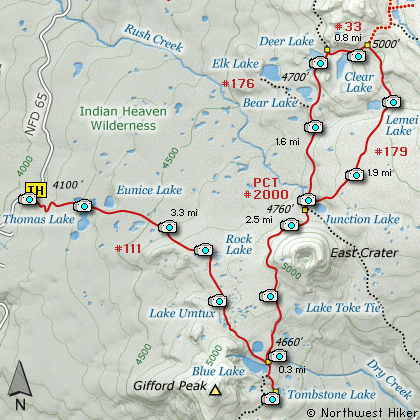
This long but extraordinary hike begins
off Forest Road #65 on the west side of
the Indian Heaven Wilderness Area. This
hike is a grand tour of the central lake
system and offers fantastic visual rewards.
The trail climbs immediately as it works
its way from a logged off area into a
densely forested area. Because of the
elevation of the Wilderness the trees
do not get very large in stature. However,
in season the mosquitos to, so come prepared.
During mid-summer this entire hike is lined
with wonderful displays of wildflowers.
In about a half mile you begin encountering
some of the many lakes you will see along
this hike. Thomas Lake is the first large
lake on your right. The hike to this alone
makes the trip worth it, but there is much
much more.
After passing this lake you will begin to
gain elevation again. From time to time
you will see other lakes and meadows along
the way. At one point you will be able to
see Mt St Helens to the west. Soon you
will come to Rock Lake. Here the trail
turns south and makes its way through more
meadows and past more lakes on its way
to the junction with the Pacific Crest
Trail (PCT #2000). You will loose a bit
of elevation as you approach Blue Lake
and the PCT.
While you are here, take the short side
Trail #55 to Tombstone Lake about a
quarter mile away. Then return to the
PCT and head north.
The trail will now climb quite a bit as
it makes its way around the west side
of East Crater. It is about 2.4 miles
from Blue Lake to the junction with
Trail #48 at Junction Lake. At this
intersection, chose Trail #179 and follow
it around the south side of the lake.
Trail #179 will take you uphill on its
way to Lemei Lake. In about a mile the
trail breaks out on a ridge where you
can see Lemei Lake below. The trail
descends and passes along the east side
of the lake. After passing Lemei Lake,
the trail veers off to the northwest
and climbs as it makes it way to the
junction with Trail #33 from Cultus
Lake.
When you reach this junction bear left
and follow the trail downhill past Clear
Lake. About a half mile further you
will come to the junction with PCT #2000
which you left back at Junction Lake.
Now bear left and rejoin the PCT and
head south.
Soon you will pass Deer Lake, which
is just a short walk off the trail.
Then back to the PCT, and the next
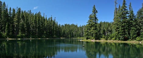
lake which is Bear Lake. This is an
interestingly shaped lake, and well
worth a little time to explore.
Then back on the trail heading south
to Junction Lake and on to Blue Lake
where you first met the PCT.
Here you bear right and follow Trail #111
past Rock Lake and Thomas Lake as you
return to the trail head where you began
this adventure.
Bear Lake
|
How to get there:
NEW!
Click for PDF Directions Map of this Hike
From Portland, OR
From Portland, travel east on Interstate Hwy 84 to Exit 44 to Cascade Locks.
Exit the freeway and cross over the Columbia River into Washington
via the Bridge of the Gods. Then turn right, or east, and head
east through Stevenson, Washington to the intersection of the Wind
River Highway to Carson, Washington. Bear left onto the Wind River
Highway which will take you through Carson, Washington.
from Vancouver, WA
From Vancouver, WA travel east on SR14 through Stevenson, Washington to the
intersection of the Wind River Highway to Carson, Washington. Bear left onto the
Wind River Highway which will take you through Carson, Washington.
from Carson, WA
Continue north on the Wind River Highway for about 5.8 miles to the
junction of the Wind River Hwy and the Old State cutoff road east. In just a few hundred
feet turn left, north, onto Forest Road 65. In another 4.7 miles you
will pass Forest Road 68. Continue north on FR65 for another 6.1 miles
and you will pass Forest Road 60. Continue north on FR65 another
8.3 miles and you see the parking area for the trailhead to this hike.
|