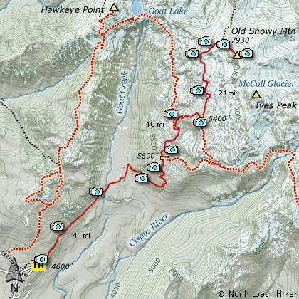
Length: 14.2 Mile Round Trip
Elevation Change: 3630' Cumulative Elevation gain
Season: Mid-Summer thru Fall
Difficulty: Difficult
Permit: NW Forest Pass Required
Features:
This is one of the most popular hikes in the
Goat Rocks and after you've completed this
journey, you will know why.
This hike begins at the same trail head as
the Snowgrass Flats hike and follows the
same trail to Snowgrass Flats. Then you
follow the cut-off trail that takes you to
the Pacific Crest Trail above Snowgrass Flats.
Upon reaching the PCT, you follow it north
until you reach the pass on the northwest
flank of Old Snowy itself. From there you
follow a users trail to the top.
You are likely to encounter alot of other
ambitous hikers, but this should not destract
from the awesome beauty around you. If you
can hike this in mid July to early August you
will be treated to incredible floral displays
with a few not so friendly insects who attempt
to distract you for the beauty of your surroundings.
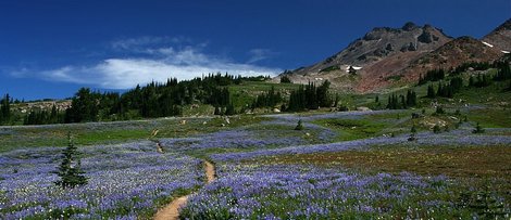
Old Snowy rises above a wildflower meadow
|
How to get there:
NEW!
Click for PDF Directions Map of this Hike
From I-5 junction with US Hwy 12
Travel east on US Hwy 12 for about 48 miles to Randle.
From Randle travel east on US Hwy 12 for about 13.3 miles to the junction with
Forest Road 21. Turn right (south) onto FR21 and follow it uphill for about 5 miles.
At this point you will see Forest Road 2110 on your left, which is the road to the
Glacier Lake trailhead, but you continue straight ahead on FR21. In another 8.1 miles
you will come to the junction of Forest Road 2150. Bear left onto FR2150 and follow it
about 3 miles and you will pass the junction on your left which leads to the
Chamber Lake campground. Continue ahead just a short distance, and you will come to
a spur road on your right. This is the entrance to what is referred to as the
Snowgrass Flats trailhead. This hike and many more begin here.
|