Length: 16 mi RT
Elevation Change: 2600' gain
Season: Summer thru Fall
Difficulty: Very Difficult
Permit: Observatory Pass Required
Features:
This is a long but rewarding approach to Mount Margaret. The hike begins
at the Johnston Observatory on Johnston Ridge. Keep in mind that if you
choose to hike from this location, you may need a permit to park in the
Observatory parking area.
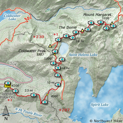
The hike follows the Boundary trail from the Johnston Ridge Observatory
all the way to Mount Margaret. This is the same route to Harry's Ridge,
and Coldwater Peak. So, the description is identical up to the point where
the Boundary Trail leaves the junction to Coldwater Peak.
From that junction to Mount Margaret the trail winds its way across the
volcanic barren landscape past what is called The Dome. This is a large
rock outcropping which is a destination in itself.
As the trail circles to the north of St. Helens Lake, you get great vistas
looking back toward Mt. St. Helens and Coldwater Peak. Then eventually, the
trail breaks over the ridge so you can see Mt. Whittier and Mt. Rainier
rising up behind Mt. Whittier.
In season this trail is surrounded by a great diversity of wildflowers which
add to the joy of this adventure. From the summit of Mount Margaret you
can see Mt. Rainier to the north, the Goat Rocks to the northeast, Mt. Adams
to the east, Mt. Hood to the southeast and Mt. St. Helens directly south, as
it rises above Spirit Lake.
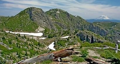
Mt. Margaret and Mt. Adams from the Boundary Trail
|
How to get there:
NEW!
Click for PDF Directions Map of this Hike
From Seattle, WA
Drive south on I-5 to the junction of State Road 504. Exit the freeway, and turn
left (east) onto SR504 and follow it east. At five miles you will pass the Silver Lake
Visitor Center and in another 38 miles you will come to the junction to SR504 E.
Bear right onto SR504 East and follow it another 8 miles to the Johnston Ridge Observatory.
(closed in winter)
From Portland, OR
Drive north on I-5 to the junction of Washington State Road 504. Exit the freeway, and turn
right (east) onto SR504 and follow it east. At five miles you will pass the Silver Lake
Visitor Center and in another 38 miles you will come to the junction to SR504 E.
Bear right onto SR504 East and follow it another 8 miles to the Johnston Ridge Observatory.
(closed in winter)
|