

|
THE FOLLOWING MAP IS NOT TO BE USED FOR NAVIGATIONAL PURPOSES.
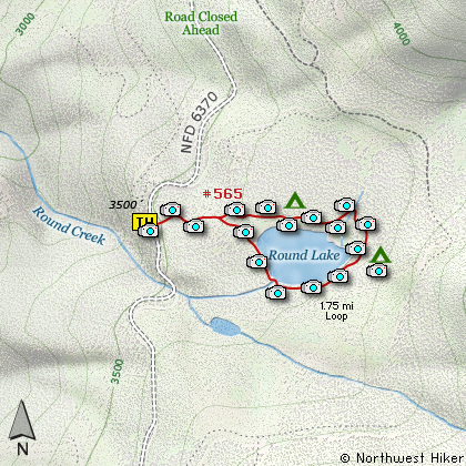
Map of the Round Lake Hike
|
Length: 1.5 mi RT
Elevation Change: 100' gain
Season: Summer thru Fall
Difficulty: Easy
Permit: NW Forest Pass Not Required
Features:
NEW!
Click for PDF Topo Map of this Hike
Round Lake and its associated camp facilities are extremely run down. However, it appears
that various volunteer groups are doing their best to breathe new life into this special
get away.
The road was in very good condition, so getting here should not be an issue. The hike is extremely
short, and thus reaching the campground, which is actually a walk-in campground along the lake, is
also very easy. It is about a half mile walk, and uphill at first, to get to the lake's north shore.
The north shore is the most developed and offers the best camp sites. However, even though the trail does
go completely around the lake, well, it is in very poor repair.... especially the bridge across the outlet
stream.
I really liked this lake, and appreciated all the hard work volunteers have done to make this
a worthwhile destination. Every time I looked at the lake, I saw trout jumping. There is a
two fish per day limit, and I am sure you will have no problem reaching this limit with the
whole family.
When I hiked to the lake in mid-July the Rhododendrons were in full bloom, and oh, what a treat.
No wonder they call the ridge above the lake Rhododendron Ridge. This kind of environment does
come with a price.... mosquitos. Yup, cazillions of them. So, simply come prepared during the
hatch, or come later in the summer and have less hassle. But, whatever you do... come and enjoy
this little gem tucked away in the back country of the Mt. Hood National Forest.

Round Lake
|
How to get there:
NEW!
Click for PDF Directions Map of this Hike
This is one of the easier trailheads to get to. Just head south out of Estacada on Hwy 224,
to the Ripplebrook Ranger Station. Continue south from there on Forest Road 46 for about another
27 miles, and keep an eye open for Forest Road 6350 on your right (west). Turn onto FR 6350
and stay on this road for about 4.7 miles until you come to FR 6355. Bear left (west) onto
FR 6355 for about a quarter mile and you will come to the junction of FR 150.
Turn left onto FR 150 and follow it downhill to FR 220, then continue downhill to FR 6370.
FR 6370 is a major road that used to take travelers from the Detroit Lake area to the
Collawash River, but not now. The day I hiked to Round Lake, I drove as far as one could
drive on FR 6370, hoping that just maybe the road had been repaired, even though the signs
said it was closed 5 miles ahead. It was closed alright. It had the appearance of having
been removed.... ugh. So, don't try to go home this way. Pay attention to the signs, and
if you have any questions as to whether this road or that road is open or closed, call the
Forest Service in Estacada: 503-630-8787.
|
|
|
A Virtual Hike of the Mount Hood National Forest


|
|


