

|
THE FOLLOWING MAP IS NOT TO BE USED FOR NAVIGATIONAL PURPOSES.
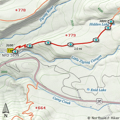
Map of the Hidden Lake Hike
|
Length: 4 miles round trip
Elevation Change: 700' gain
Season: Late Spring thru Late Fall
Difficulty: Moderate
Permit: NW Forest Pass Required
Features:
NEW!
Click for PDF Topo Map of this Hike
This is a short and moderate hike. The hike begins to climb almost
immediately and climbs along the side of a steep hillside within a dense forest. About
a half mile into the hike you are offered the only opportunity for a view. At that point
the trail levels off and remains an easy walk the rest of the way to the lake. Depending
on the season, the Hidden Lake can resemble a large marshy pond. You must cross the outlet
stream just before the lake and this can be tricky.
If you would like a more significant challenge, after viewing the lake, continue on Trail #779
to the point it meets the Timberline Trail #600 (also the Pacific Crest Trail #2000). The
only reason to take this difficult hike would be for the exercise or adventure. There are
not significant viewpoint the entire distance.
|
How to get there:
NEW!
Click for PDF Directions Map of this Hike
Follow US 26 about 4 miles east of Rhododendron
to Road 2639, marked by a sign indicating the
Kiwanis Camp. Turn left onto this paved road
and follow it for about 2 miles. There is a
large turnout on the left side of the road
indicating the trailhead for Hidden Lake.
If you come to the end of the road, which
would be the trailhead for Little Zig Zag Falls,
then you have gone too far.
|
|
|
A Virtual Hike of the Mount Hood National Forest


|
|


