Length: 14 mi RT
Elevation Change: 2700' gain
Season: Summer thru Fall
Difficulty: Difficult
Permit: NW Forest Pass Required
Features:
NEW!
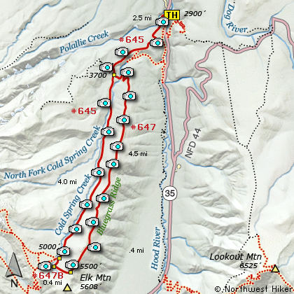
Click for PDF Topo Map of this Hike
This is a difficult hike with exceptional rewards and challenges. This hike is NOT
for everyone. ONLY those with alot of experience in crossing fast moving creeks
should even consider this hike.
The trailhead is
along state highway 35 and is marked Polallie. You have to cross highway 35 from the
parking area, so use extreme caution due to the fast, high volume traffic along this
stretch of the road.
The trail that you use to begin this hike is the same trail you can use to reach
Tamanawas Falls, so the first mile and a half are well traveled and in excellent
condition. Also you are likely to meet other hikers on this first part of the hike,
but after you pass the junction to Tamanawas Falls, you will most likely not see
another soul until you reach Elk Meadows.
The biggest challenge of this hike is not the 14 miles and the 3000 feet of cumulative
elevation gain, but it is the two crossings of Cold Springs Creek. Each time that I
have done this hike, I have had no problems getting across the creek while hiking up
to Elk Meadows, but each time I complete the ridge loop and have to cross the creek to
get back to the trail leading back to the trailhead, well, this is a serious problem.
But, more about that later.
After passing the junction to Tamanawas Falls, you will enter the Mt Hood Wilderness
where you are to sign in. About a mile later you will come to the junction of the
trail that you will use as your return route, completing the Bluegrass Ridge loop part
of the hike. Continue on the main trail as you hike towards Elk Meadows. Then in about
another mile the trail crosses Cold Springs Creek. If the water is too high to wade,
you will have to find fallen debris along the creek and carefully make your way to the
other side.
Once on the other side, the trail climbs as it parallels the creek. In about another
mile, if the weather if favorable, you will be able to catch glimpes of Mt Hood just to
the west of you. In another mile you will come into an area that was badly burned in
a forest fire back in 2006. The hike will take you in and out of burned areas for the
next mile or so, but when you reach the junction at Elk Meadows, you will find the
forests still lush and green.
At this junction, I usually go straight ahead and walk out into Elk Meadows. There is
a shelter there and again, if the weather if favorable, you will be treated to world
class views of Mt Hood. In season, the meadows are overflowing with wildflowers. After
your time here, return to the previous junction and head east toward the cutoff trail
that will take you up a steep 500 foot climb onto Bluegrass Ridge. Even though most of
the area that you will now hike in has been badly burned, cairns and markers are in
place to keep you on the trail.
When you reach the top of the ridge, and hike north along Bluegrass Ridge, fantastic views
await you, if of course the weather cooperates. To the south is Mt Jefferson, and to the north
you will see Mt Adams, Mt Rainier, and Mt St Helens from time to time. All the while,
magnificent Mt Hood is standing there in full view on your west side. Below you on the
east side is the West Fork of the Hood River and rising to the east of that is Lookout Mtn.
In spite of the terrific damage left behind from the forest fire, the trail does pass through
occasional live standing timber. In season this ridge is a floral garden, and in the fall
you get to enjoy the colorful mountain larches as they turn gold. As the trail works its way
north along the ridge, it slowly loses elevation. At times you will pass through dense young
forests full of debris. The last half mile of the ridge, the trail really begins to descend
toward Cold Springs Creek. And here will be your greatest challenge.
The crossing of the creek is so dangerous, that I felt it necessary to say so in RED.
It took me some time to find a log of adequate size and stability to manage a way
across Cold Springs Creek. BE AWARE OF THIS REQUIREMENT BEFORE YOU DECIDE TO TAKE
THIS HIKE. It is a very long walk back the way you came, if you cannot find a safe
way across this creek. And keep in mind, that there is inherent danger in crossing
any creek, much less doing so by walking or crawling across on a log. Trail reports
as recent as June 2015 are that there are several downed trees on the west side of
the loop and GPS navigation is extremely recommended for this hike.
There used to be a fine bridge here, but it was washed out long ago.
Once you get across the creek, it is a short hike back to the main trail that will
take you back to the junction you passed earlier and to the trailhead where you began
this adventure.

Mt. Hood seen from Elk Meadows
|