Length: 3.8 miles round trip
Elevation Change: 500' gain
Season: Late Spring thru Late Fall
Difficulty: Easy
Permit: NW Forest Pass Required
Features:
NEW!
Click for PDF Topo Map of this Hike
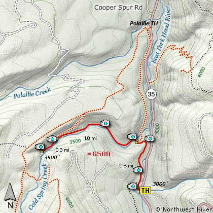
There are basically two approaches to Tamanawas Falls. This hike begins
at the Tamanawas Falls Trail head along highway 35. After crossing the East Fork of the Hood
River, turn right on Trail #650 and follow the river for about a half mile. Then the trail
takes a sharp left turn on the point of a cliff with a great view and heads into the
Cold Spring Creek Canyon. Soon you intersect Trail #650A which is directly ahead of you
as Trail #650 makes a sharp right and continues on its way to the Polallie Trail head.
You now continue upstream and cross a fine log bridge across Cold Spring Creek. The trail
follows the creek literally all the way to Tamanawas Falls. However, about a quarter mile
before the falls you intersect Trail #650B which takes to over a ridge to the Polallie Trail head.
Because of a bridge washout, you must continue across a rather shabby trail for a couple hundred
feet before regaining the original trail which takes you around a couple bends and to Tamanawas Falls.

Tamanawas Falls
|