

|
THE FOLLOWING MAP IS NOT TO BE USED FOR NAVIGATIONAL PURPOSES.
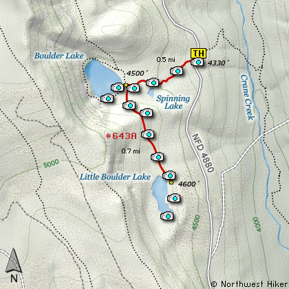
Map of the Boulder Lakes Hike
|
Length: 4 mi RT
Elevation Change: 310' gain
Season: Summer thru Fall
Difficulty: Easy
Permit: NW Forest Pass Not Required
Features:
NEW!
Click for PDF Topo Map of this Hike
This is a fairly popular little hike that can be enjoyed by the whole family.
The elevation is over 4000 feet, so this is a great get-away-from-the-heat hike
during the long summer days.
The parking is limited at the trailhead for this hike, so you may have to park a
bit further from the trail than you desire. Nevertheless, this is a great hike and
will worth the trouble to find a place to park.
The trail climbs rather sharply at first but only for a short distance, as the trail
itself is only a half mile long. As you climb through a dense forest of fir and hemlock,
you will pass a little pond to your left. In summer, this could pose a mosquito problem,
so come prepared. Of course, the lake area itself will likely pose the same problem.
Just before you reach the lake you will come to a junction. Just continue on straight
ahead to the lake, and enjoy the water, scenery, and fun. I recommend taking the short
walk over to Little Boulder Lake.
The trail is steep at first, but again, it is a very short walk over to the other, smaller
lake. Both lakes are great destinations. The Little Boulder Lake is actually only a very
short distance off the road you just came in. And you could park here, and walk the trail
not only to Little Boulder Lake, but also north to the larger lake. Either way, this is a
fun adventure.
Enjoy!

Boulder Lake
|
How to get there:
NEW!
Click for PDF Directions Map of this Hike
From Portland, follow US 26 east past Government Camp to the junction with Hwy 35.
Follow Hwy 35 south toward Mt. Hood Meadows until you cross the White River. Immediately
after the bridge, on your right is Forest Road 48. Turn right and head east on FR 48.
From Hood River, follow Hwy 35 south past the Mt. Hood Meadows ski area to the bridge
that crosses the White River. Just before the bridge, turn left onto Forest Road 48,
and follow this road approximately 13.9 miles east. At about 8.9 miles you will pass
the junction with Forest Road 43 on your right, but just keep going east. In another
5 miles you will come to Forest Road 4880 on your left. Watch carefully, as this
junction is on a curve on FR 48.
Follow Forest Road 4880 north for about 6.5 miles and you will come to the well marked
trailhead to Boulder Lakes.
|
|
|
A Virtual Hike of the Mount Hood National Forest


|
|


