

|
THE FOLLOWING MAP IS NOT TO BE USED FOR NAVIGATIONAL PURPOSES.
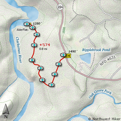
Map of the Alder Flats Hike
|
Length: 1.6 mi RT
Elevation Change: 215' loss then re-gain
Season: Summer thru Fall
Difficulty: Easy
Permit: NW Forest Pass Not Required
Features:
NEW!
Click for PDF Topo Map of this Hike
Here is a hike to a very popular destination in the heat of summer. The hike
down to Alder Flats takes a winding route through tall old growth timber to the
shore of the incredible Clackamas River. Depending on the season, you can encounter
a large variety of wildflowers and even wild geese heading north or south on the little
ponds along the way.
In the heat of summer, the Clackamas River provides a refreshing relief and natural
beauty to boot. There are a number of camp spots along the river at trails end, but
however long you plan to stay, this little hike is a rich reward.

The Clackamas River runs along Alder Flats
|
How to get there:
NEW!
Click for PDF Directions Map of this Hike
Follow Hwy 224 southeast out of Estacada for about 24 miles. Just after the Timber Lake
Work center exit, you will come to the trailhead for Alder Flats Campground on your right.
If you come to the Ripplebrook Ranger Station, you have gone just a little too far.
|
|
|
A Virtual Hike of the Mount Hood National Forest


|
|


