

|
THE FOLLOWING MAP IS NOT TO BE USED FOR NAVIGATIONAL PURPOSES.
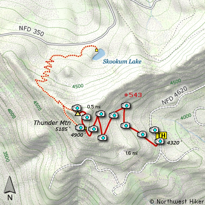
Map of the Thunder Mountain Hike
|
Length: 3.2 mi RT
Elevation Change: 966' gain
Season: Summer thru Fall
Difficulty: Challenging
Permit: NW Forest Pass Not Required
Features:
NEW!
Click for PDF Topo Map of this Hike
Because it is so challenging to get to the trailhead of this little hike, there are not
many who make the effort to enjoy this little gem. I made a point of it to schedule a
second hike that day. However, if you have a family or elderly hikers, this might be just
the ticket for a day's adventure.
The road bringing you to the trailhead gets worse by the mile, but it never gets terrible.
When you approach the trailhead, it looks like the road is going into a forest and then
simply stops. But, the road actually makes a slight turn to the left and passes the trailhead.
What looks like a road going into the dark forest, is in fact the parking area for the trailhead.
Lots of room to park, and it is well signed, so you can't miss the trail if you don't miss this
unusual trailhead.
This is a fairly short hike, but kinda steep. You start in that dark dense trailhead forest, but
move quickly out into the open where you can see Mt. Jefferson to the southeast and the Bull of the
Woods Wilderness area to the south. After an initial major switchback to the right the trail begins
to climb up into a forest of large old growth trees. The climb is steady and steep in places.
You will have to step over a small stream or two, but all in all the climb is easy.
After a mile or so, the trail comes to a very sharp switchback to the left, but at the corner you
are treated to great views of the surrounding mountains, including Olallie Butte and Mt. Jefferson.
In another half mile or so and a few switchbacks the trail makes a sharp turn to the right and climbs
kinda steeply through what appears to be a logged area to a junction. This junction is to the trail
that comes from, or to depending how you look at it, Skookum Lake. Actually, if you are interested
and able, you could make a side trip down to Skookum Lake.
Anyway, bear right at this junction and continue your climb up Thunder Mountain. Soon you will come
to a place in the trail where you begin to catch glimpses of Mt. Hood to the northeast. After a
couple switchbacks, the trail brings you out on top of Thunder Mountain. Because the trees have
grown up so much around the summit, you won't get the spectacular views they did in the past when
a fire lookout sat on this peak. Nevertheless, you still get great views of Mt. Hood to the northeast,
Mt. Jefferson to the southeast, and Table Mountain to the southwest.

Mt. Hood as seen from the Thunder Mountain trail
|
How to get there:
NEW!
Click for PDF Directions Map of this Hike
Follow Hwy 224 southeast of Estacada approximately 25 miles until it becomes
Forest Road 46 just after the Ripplebrook Ranger Station and the junction with
Forest Road 57. Continue south for about another 3.7 miles to the junction
with Forest Road 63. Bear right onto FR 63 and cross over the Clackamas River.
The road now follows the Collawash River for approximately 3.4 miles.
Keep an eye open for Forest Road 6320 which will be on your right. If you miss
this road you will almost immediately come to the junction with Forest Road 70.
In which case you need to turn around.
Once you locate FR 6320 follow this road west and up hill for about a mile, and
you will come to a junction with FR 6322. Bear right and follow FR 6322 uphill
for about 5 miles until you come to the junction with Forest Road 4620. Bear left
on FR 4620 and follow it about 3 miles to the trailhead for Thunder Mtn hike.
The trailhead appears as a dead end road, with FR 4620 kinda veering off to the left.
Just drive straight ahead into the parking area and you will then see the signs,
indicating that you are in the right place.
|
|
|
A Virtual Hike of the Mount Hood National Forest


|
|


