

|
THE FOLLOWING MAP IS NOT TO BE USED FOR NAVIGATIONAL PURPOSES.
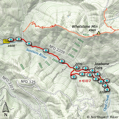
Map of the Opal Creek Recreation Area Hike
|
Length: 7 mi RT
Elevation Change: 300' gain
Season: Late Spring thru Late Fall
Difficulty: Moderate
Permit: NW Forest Pass Required
Features:
NEW!
Click for PDF Topo Map of this Hike
The hike to Jawbone Flats and the Opal Creek
Pools is a fun and enjoyable hike along the
Little North Santiam River.
There are facilities at Jawbone Flats that
can be used to stay overnight if you make
the appropriate reservations.
The trail to Jawbone Flats follows an old
road that is still used to transport items
for those that are staying overnight at the
privately run facilities.
It is about 3 miles of easy road walking to
Jawbone Flats, then a short 1/4 mile to the
wonderful Opal Creek Pools.
You can return part of the way by using the
trail on the south side of the river.

Opal Creek
|
How to get there:
NEW!
Click for PDF Directions Map of this Hike
Travel east of Salem approximately 22 miles to the community of Mehama. Turn left onto North Fork Road,
and follow it for about 15.3 miles where it becomes Forest Road 2209. Continue on FR 2209 for a little
over mile where it forks with FR 2207. Bear left to stay on Forest Road 2209, and follow it another 4
miles to the trailhead. This road is gated at the trailhead, but useable by those who have reservations at Jawbone Flats.
|
|
|
A Virtual Hike of the Mount Hood National Forest


|
|


