Methow RDe Chelan RD Entiat RD Wenatchee RD Cle Elum RD Naches RD National Foest
Okanogan-Wenatchee National Forest
Methow Ranger District

Blue Lake Hike


Click on above image to return to graphic


Click to view product details


National Forest
Annual Pass
Oregon and Washington


Washington State
Discovery Pass


Oregon State
Recreation Passes

THE FOLLOWING MAP IS NOT TO BE USED FOR NAVIGATIONAL PURPOSES.

MAP OF THE BLUE LAKE HIKE


Topo Map

Profile

Slide Show


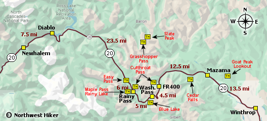
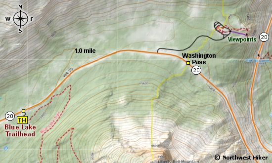
Length: 5.0 miles round trip
Elevation Change: 987' gain
Season: Summer thru fall
Difficulty:   Moderate
Permit:
  NW Forest Pass Required
Latitude:   48.5192
Longitude:   -120.6718

Features:

This is a great little hike that takes you up a steep trail to a beautiful lake near the base of the Liberty Bell complex, which is extremely popular for climbers.

The trail head is just off Hwy 20 and the views are already great. The steep climb up to Blue Lake is well rewarded not only at the lake but along the way. Looking to the west/nw you get great views of the Cutthroat Pass area.

This is a high altitude lake, so be aware that it can be frozen into late summer.


Blue Lake from the upper trail


How to get there:

   Trailhead:   N48.5192, W120.6718 (click for directions)  


Hike Difficulty Calculator

Calorie Burn Calculator

The 10 Essentials
Bear Encounters

Cougar Encounters

River Crossing Safety

A Virtual Hike of the Okanogan-Wenatchee National Forest


Click to View Instructions