Length: 4.2 miles round trip
Elevation Change: 1106' gain
Season: Summer thru Fall
Difficulty: Moderate
Permit: NWF Pass Not Required Self issue Wilderness Permit Required
Latitude: 46.7160
Longitude: -121.1657
Features:
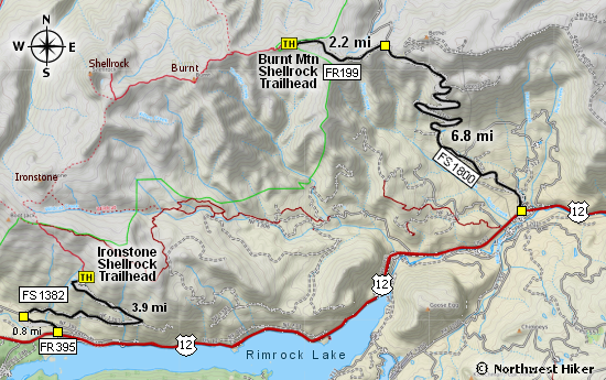
This gem of a hike is relatively easy to get to and not far from a very
busy hiking area. For the most part the road to the trail head is in
extremely good condition, probably due to the recent logging activity.
To date, a permit is not required at this trail head, but always do a
little research before you go, or just be sure to place your NW Forest
Pass on your dash, just in case.
This hike is entirely within the William O. Douglas Wilderness, so you
must sign in at the trail head. After a short walk, you will come to the
first of many fantastic viewpoints, where you see Mt. Adams to the south,
and Mt. Rainier to the west. After this, the trail drops steeply for a
couple hundred feet, so watch you footing.
 One of the best rewards for hiking in this area, is the likelihood of coming
across a herd of mountain goats. The day I hiked this trail, I saw over 40
goats on the hillside below the trail. This particular herd was several hundred
feet below the trail and about a 1/2 mile away. Nevertheless, they were not
disturbed by our presence and were easy to photograph.
One of the best rewards for hiking in this area, is the likelihood of coming
across a herd of mountain goats. The day I hiked this trail, I saw over 40
goats on the hillside below the trail. This particular herd was several hundred
feet below the trail and about a 1/2 mile away. Nevertheless, they were not
disturbed by our presence and were easy to photograph.
I hiked this trail in the first week of July and I took photos of over 45
different species of wildflowers. Actually, it was the rumor of wildflowers
that drew me to this fairly obscure hike, and I was richly rewarded.
 The trail number is 1141, and it is called the Iron Mountain Trail, because
the trail does eventually reach Iron Mountain, but not in this description.
About half way to Burnt Mountain, you will come to a junction of a trail
referred to as the Burnt Mountain Tail #1140. Nevertheless, you will continue
on Trail 1141 to Burnt Mountain.
The trail number is 1141, and it is called the Iron Mountain Trail, because
the trail does eventually reach Iron Mountain, but not in this description.
About half way to Burnt Mountain, you will come to a junction of a trail
referred to as the Burnt Mountain Tail #1140. Nevertheless, you will continue
on Trail 1141 to Burnt Mountain.
The trail losses elevation as you hike toward Burnt Mountain, but when you reach
the base of the mountain, the trail climbs very steeply up onto the southern
shoulder of the peak, and then a user trail leads you to the top.
The views from the summit are just incredible. You see Mt. Aix to the north,
Mt. Bismark, and of course Mt. Rainier, and the Goat Rocks and Mt. Adams to the south.
This is one of the most rewarding hikes you can do for such little effort.

Mt Adams from the Burnt Mtn trail
|