Length: 10 miles round trip
Elevation Change: 1990' gain
Season: Summer thru fall
Difficulty: Challenging
Permit: NW Forest Pass Required
Latitude: 46.9175
Longitude: -121.2331
Features:
This is one of the truly spectacular hikes in the
Washington Pass Area.
The hike begins at the trail head off SR20 near Rainy Pass.
This is the western approach to Cutthroat Pass using the Pacific
Crest Trail.
The hike begins in a heavily forested area and crosses several
significant streams. About 1.75 miles into the hike, the trail
crosses Porcupine Creek on a substantial bridge. After this
crossing, the trail begins to climb. Also, the trail is more
out in the open, providing world class views along the way.
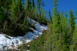
Even in July, you will most likely encounter a lot of snow
along the way as you gain altitude.
In season the wildflowers are excellent, but in all
seasons the views are world class.

Looking south towards Rainy Pass with Glacier Peak in the distance
|