Length: 9.4 miles round trip
Elevation Change: 3431' gain
Season: Summer thru fall
Difficulty: Very Difficult
Permit: NW Forest Pass Required
Latitude: 46.9177
Longitude: -121.2303
Features:
 This is one of the trails that leads to the summit of Goat Peak, which lies on the American Ridge.
I prefer this approach because it is more gentle and offers amazing views and in season, a large
variety of wildflowers.
This is one of the trails that leads to the summit of Goat Peak, which lies on the American Ridge.
I prefer this approach because it is more gentle and offers amazing views and in season, a large
variety of wildflowers.
Goat Peak is located in the William O Douglas Wilderness Area, so you will need to fill out a
wilderness permit at the trailhead. The trail starts out very gentle before entering the
actual wilderness, but then the climb begins. As you gain elevation, you will be treated to
various views of the surrounding mountains. Unfortunately, there was a naturally caused
forest fire a few years ago, so the forest across the valley shows signs of the burn.
 Beginning in June, the wildflowers on this hike are spectacular. Each week reveals a new
variety of flowers and butterflies. In late May or early June, the upper slopes of the
trail are surrounded by glacier lilies. Later in the June the lupine appear as well as
a number of other high elevation wildflowers. If you are fortunate, you may even come across a pine marten
and/or mountain goats.
Beginning in June, the wildflowers on this hike are spectacular. Each week reveals a new
variety of flowers and butterflies. In late May or early June, the upper slopes of the
trail are surrounded by glacier lilies. Later in the June the lupine appear as well as
a number of other high elevation wildflowers. If you are fortunate, you may even come across a pine marten
and/or mountain goats.
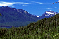
 At approximately 3.7 miles, you will come to the junction of the American Ridge trail. Follow this
trail to the right/east and in another mile you will reach the summit of Goat Peak. At this point
the trail begins to get steeper and steeper, but if also offers world class views of Mt. Rainier and
the surrounding peaks, including Mt. Adams to the south/southeast.
At approximately 3.7 miles, you will come to the junction of the American Ridge trail. Follow this
trail to the right/east and in another mile you will reach the summit of Goat Peak. At this point
the trail begins to get steeper and steeper, but if also offers world class views of Mt. Rainier and
the surrounding peaks, including Mt. Adams to the south/southeast.
Just before the summit, you will need to leave the American Ridge trail, and follow an obvious
approach to the summit of Goat Peak. From there on a good weather day, you will be able to
enjoy views of the mountain in the Stuart Range to the north, and the Goat Rocks to the south.

Mt Rainier from the Goat Peak trail
|


