Methow RDe Chelan RD Entiat RD Wenatchee RD Cle Elum RD Naches RD National Foest
Okanogan-Wenatchee National Forest
Methow Ranger District

Lookout Mountain Hike


Click on above image to return to graphic


Click to view product details


National Forest
Annual Pass
Oregon and Washington


Washington State
Discovery Pass


Oregon State
Recreation Passes

THE FOLLOWING MAP IS NOT TO BE USED FOR NAVIGATIONAL PURPOSES.

MAP OF THE LOOKOUT MOUNTAIN HIKE


Topo Map

Profile

Slide Show


Length: 3 miles round trip
Elevation Change: 1170' gain
Season: Summer thru fall
Difficulty:   Difficult
Permit:
  NW Forest Pass Required
Latitude:   48.3246
Longitude:   -120.1847

Features:

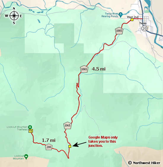
this is a popular little hike with easy access. The trailhead is about 6.5 miles from SR20 in Twisp and the road is in good condition.

I classify this hike as difficult because of the significant elevation gain in such as short distance. However, the shortness of the hike makes it feel easier.

The majority of the hike is in forested areas but there are many times the trail is out if in the open. This provides many opportunities to view the surrounding mountains. In season, this is a very floral hike.


Looking west from the Lookout Mtn trail


How to get there:

   Trailhead:   N48.3246, W120.1847 (click for directions)  

Note: Google Maps cannot take you to the trailhead,
but continue forward to the trailhead.


Hike Difficulty Calculator

Calorie Burn Calculator

The 10 Essentials
Bear Encounters

Cougar Encounters

River Crossing Safety

A Virtual Hike of the Okanogan-Wenatchee National Forest


Click to View Instructions