Length: 7.5 miles round trip
Elevation Change: 2205' gain
Season: Summer thru fall
Difficulty: Difficult
Permit: NW Forest Pass Required
Latitude: 47.0886
Longitude: -121.1752
Features:
This hike is an OTV path and is used by motorcycles and mountain bikes.
Trail 947 actually begins near the Little Naches River Road, but for
hiking purposes, follow the directions to the best suited trail head.
This is a wonderful hike and not frequently used. There are a couple
of ways to access the trail. One option is the start your hike where
the trail crosses the road very close to the actual trailhead.
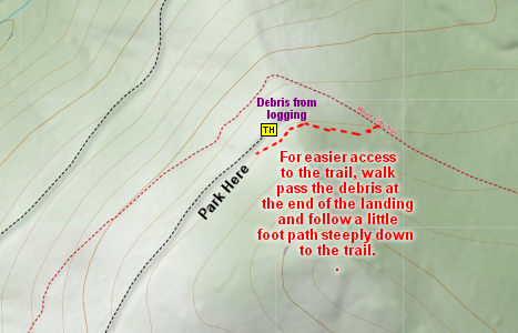
The other option, which I prefer, is to drive to the end of the road
as illustrated on the map below, and park near the logging debris.
At this point you will be above the trail, so the easiest way to
climb down to the trail is to walk past the debris on the uphill
side and follow a user path down to the actual trail.
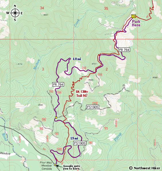
The Mount Clifty hike offers several options. I have illustrated what
I call a lasso hike, where you hike to a certain point and then do
a loop returning to the trail you used to access the loop.
The path illustrated connects with several other trails that follow
the Manatash Ridge, so it is good to take note of the junctions.
For the hike as I illustrated it, just keep selecting the trail to
the right until you complete the loop.
On a clear day you will be treated to world class views of the Cascade
Mountains from Mt. Adams to the south behind the Goat Rock, to Mt. Rainier
to the west, to the Stuart Range to the north with Glacier Peak in the
distance.

Looking north toward the Stuart Range from the summit of Mt Clifty
|