|
|
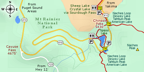
THE FOLLOWING MAP IS NOT TO BE USED FOR NAVIGATIONAL PURPOSES.

MAP OF THE NACHES PEAK LOOP HIKE
|
Length: 4.25 miles round trip
Elevation Change: 725' gain
Season: Summer thru fall
Difficulty: Moderate
Permit: NW Forest Pass Required
Latitude: 46.8753
Longitude: -121.5173
Features:
This is another world-class hike that is easily accessible therefore it is very
popular and the trail is often crowded. However, I was not surprised to see very
few hikers mid-week. The trailhead is located at a fine parking area just a short
distance east of Chinook Pass and is complete with a couple of restrooms, which are
overused on the weekends.... so, Monday's the restrooms are pretty useless.
I recommend that you park at the Chinook Pass parking area as described above,
and hike this loop clockwise so that you have the very best vistas of Mt. Rainier
as you do a loop hike around Naches Peak.
 You begin this outstanding hike in a national forest on the famous Pacific Crest Trail.
Soon you will enter the William O. Douglas Wilderness in which you will hike for about
a mile.
You begin this outstanding hike in a national forest on the famous Pacific Crest Trail.
Soon you will enter the William O. Douglas Wilderness in which you will hike for about
a mile.
The trail gently climbs as it makes its way along the northeastern flank of Naches Peak.
At about a mile and a half, you will cross over the shoulder of the peak and catch your
first views to the south. Below you are Dewey Lake and another fine lake just to the west
of Dewey. The Pacific Crest Trail leaves the Naches Peak and descends to Dewey Lake before
continuing south to Mexico.
 This loop trail leaves the PCT and now continues west with ever-increasing majestic views of
Mt. Rainier and the Tatoosh Range to the southwest. At this point, you are actually entering
the Mt. Rainier National Park for most of the rest of this hike. In season, this entire loop
hike is covered in fields of wildflowers that change species about every two weeks or so.
Bear grass which is cyclical and regional can be very abundant if you happen to be there in the right cycle.
This loop trail leaves the PCT and now continues west with ever-increasing majestic views of
Mt. Rainier and the Tatoosh Range to the southwest. At this point, you are actually entering
the Mt. Rainier National Park for most of the rest of this hike. In season, this entire loop
hike is covered in fields of wildflowers that change species about every two weeks or so.
Bear grass which is cyclical and regional can be very abundant if you happen to be there in the right cycle.
The trail loses elevation as you hike toward Mt. Rainier and Tipsoo Lake. When you get
to highway 410, you have a choice to either cross the road and take the trail around
Tipsoo Lake, or follow highway 410 uphill and back to the parking area where you began
this adventure.
The advantage of following the highway is that you get the most incredible view of
Tipsoo Lake with Mt. Rainier in the background. If you take the trail around the lake
instead, the view is not nearly as spectacular.

Mt. Rainier from Naches Peak Loop trail
|
|
How to get there:
Trailhead: N46.8753, W121.5173 (click for directions)
From the Yakima, WA area travel on Hwy 12 about 4.5 miles west of Naches, WA.
Hwy 12 will then turn left, but you keep straight ahead on Hwy 410. Follow Hwy 410
for another 47 miles and you will come to a trailhead parking area on your right.
This trailhead connects to the Pacific Crest Trail, which for our purposes offers
two hikes. One to the north to Sheep Lake and Crystal Lake, and one to the south
to the Naches Loop Trail.
Coming from the northwest follow Hwy 410 from Enumclaw, WA for about 41 miles
then turn left and follow Hwy 410 up to Chinook Pass. Just a bit further on your
left will be this major trailhead.
Coming from the southwest follow Hwy 12 to the junction of Hwy 123. Turn left
onto Hwy 123 and follow it the junction with Hwy 410. Then turn right and
follow Hwy 410 up to Chinook Pass. Just a bit further on your left will be
this major trailhead.
|
|


