Length: 5.1 miles round trip
Elevation Change: 909' gain
Season: Summer thru fall
Difficulty: Moderate
Permit: NW Forest Pass Required
Latitude: 46.9175
Longitude: -121.2331
Features:
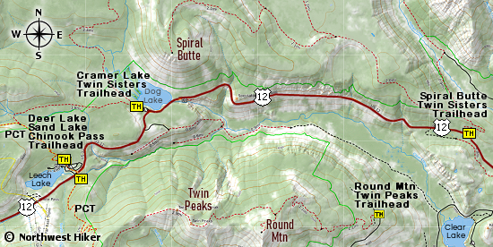
This hike is a portion of the Pacific Crest Trail.
It begins at the trailhead near White Pass, where
the PCT crosses US Hwy 12. The hike is a moderate
hike that climbs gently to first Deer Lake and
then on to Sand Lake. The majority
of the hike is in heavily forested areas.
After the first mile, you will come to the junction
of the Oak Meadow Trail on your right. About a mile
past that junction, you will come to a trail on your
left that will take you to Deer Lake.
In another half mile you will come to a clearing, where
Sand Lake is located. There are several excellent areas
to approach the lake and even walk around it.

Sand Lake
|