Length: 1.7 miles round trip
Elevation Change: 665' gain
Season: Summer thru fall
Difficulty: Moderate
Permit: NW Forest Pass Required
Latitude: 48.7394
Longitude: -120.6787
Features:
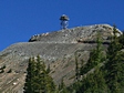 This is a hike where you walk a gated road
to the top of a peak upon which is located
a fire lookout.
This is a hike where you walk a gated road
to the top of a peak upon which is located
a fire lookout.
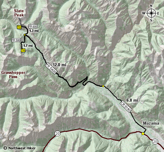
Take State Highway 20 to Mazama, 11 miles west of Winthrop.
Drive to an intersection at one mile. Turn left on Harts
Pass Road, also known as Lost Lake Road (FS Road No. 5400),
passing a general store and post office. Pavement ends at
seven miles and the road continues past the Riverbend
Campground turnoff (nine miles).
A couple of miles past Riverbend there is a half-mile stretch
of rocky road above Dead Horse Point with some exposure
(though narrow, the road is in good condition).
Just before Harts Pass the Meadow Campground Road goes
off to the left. Continue to Harts Pass at 6,198 feet
and the Harts Pass Guard Station (19 miles from Mazama)
and a split in the road. Turn right on the 3-mile
Slate Peak Road (FS Road 5400-600). Pass a switchback
at 1.5 miles and parking for the Pacific Crest Trail
and continue to the second switchback at 1.8 miles to
the Slate Pass trailhead, elevation 6,900 feet.
If there are snow patches, you will be hiking rather
than driving the road. The road is permanently gated
1/4 mile from the Slate Peak lookout.
From the Hart's Pass area you can hike the PCT to
the north below Slate Peak, or to the south past
Tatie Peak. This entire area is beautiful beyond
description.

Looking south from the trail up Slate Peak
|