|
|
THE FOLLOWING MAP IS NOT TO BE USED FOR NAVIGATIONAL PURPOSES.

MAP OF TAHTLUM PEAK VIA NACHES LOOP HIKE
|
Length: 5.5 miles round trip
Elevation Change: 1517' gain
Season: Summer thru fall
Difficulty: Challenging
Permit: NW Forest Pass Required
Latitude: 46.8753
Longitude: -121.5173
Features:
 This hike uses the Naches Loop trail and can be accessed from the Chinook
Pass bridge or the Tipsoo Lake trailhead.
This hike uses the Naches Loop trail and can be accessed from the Chinook
Pass bridge or the Tipsoo Lake trailhead.
From either parking area, follow the Naches Loop trail to the rock overlook of Dewey Lake.
Here finding the trail to Tahtlum Peak is a bit tricky. See the adjacent map for clarity.
The trail from the Dewey Lake overlook, is kinda sketchy. It doesn't appear to be used very much.
Nevertheless, I didn't have any serious problems following it to the summit of Tahtlum Peak.
The main thing is to not follow any apparent trails you come across that lead to the left.
Stay on the ridge, even though the trail is not very clear.
From the summit you will be rewarded with world class views of the surrounding mountains,
including of course, Mt. Rainier. Mt. Adams can be seen to the south and Dewey Lake
can be see below from many vantages.

Mt Adams peaking from behind Dewey Peak from the Tahtlum Peak trail
|
|
How to get there:
Trailhead: N46.8753, W121.5173 (click for directions)
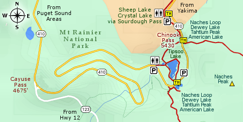
From the Yakima, WA area travel on Hwy 12 about 4.5 miles west of Naches, WA.
Hwy 12 will then turn left, but you keep straight ahead on Hwy 410. Follow Hwy 410
for another 47 miles and you will come to a trailhead parking area on your right.
This trailhead connects to the Pacific Crest Trail, which for our purposes offers
two hikes. One to the north to Sheep Lake and Crystal Lake, and one to the south
to the Naches Loop Trail.
Coming from the northwest follow Hwy 410 from Enumclaw, WA for about 41 miles
then turn left and follow Hwy 410 up to Chinook Pass. Just a bit further on your
left will be this major trailhead.
Coming from the southwest follow Hwy 12 to the junction of Hwy 123. Turn left
onto Hwy 123 and follow it the junction with Hwy 410. Then turn right and
follow Hwy 410 up to Chinook Pass. Just a bit further on your left will be
this major trailhead.
|
|


