Length: 10.5 mi round trip
Elevation Change: 2880' gain
Season: Summer thru fall
Difficulty: Difficult
Permit: Discovery Pass Required
Latitude: 46.7487
Longitude: -120.7979
Features:
The trail head for this hike is located just
off SR410 a half mile west of the junction with US Hwy12.
This is a real gem of a hike and actually has a couple of
options. But for this description, I intend to describe
the most common use of this trail by hiking from the
parking area to the junction with the Clemans Mtn.
saddle junction which is approximately 2.2 miles.
 This trail can be hiked year round if snow doesn't prevent
you from getting to the trailhead.
This trail can be hiked year round if snow doesn't prevent
you from getting to the trailhead.
As is true of many outstanding hikes, this
hike is in its glory when the spring wildflowers
are blooming. As spring progresses so do the
wildflowers, starting at the beginning of the
trail and progressing uphill as the weeks go by.
In a way, you can follow spring up the canyon
as the flowers bloom in several phases. For
those of you who enjoy photographing the wildflowers,
by the first of May the honey bees provide excellent
opportunities for awesome pictures.
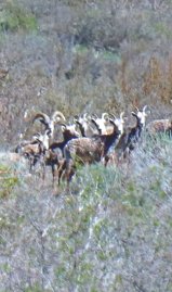 Wildflowers are a spring treat but this hike offers
another incredible treat and that is the common
sighting of the wild Big Horn Sheep. Many hikers
report seeing large numbers of sheep as well as
the occasional small number or single individuals.
Wildflowers are a spring treat but this hike offers
another incredible treat and that is the common
sighting of the wild Big Horn Sheep. Many hikers
report seeing large numbers of sheep as well as
the occasional small number or single individuals.
There are snakes in this canyon, but they seem to
be less and less common. Hikers should be aware of
the possibility of coming across a rattlesnake but
the common bull snake is more likely.

As I mentioned earlier, this is a hike that can be
enjoyed the year around. Each season brings with
it the unique environment of the varied unique
experiences.
Even though this hike is only 2.2 miles long if you
choose the saddle junction as the destination, it is
still a challenging hike in that you will gain over
1400 feet of elevation in that short distance.
 and Twisp Mtn from the Twisp Pass trail (right)")
Big Horn Sheep are plentiful in season
|


