Search West West Central East Central East Hike List Return
Hike 8 Angels Rest, Wahkeena Springs, Devils Rest Loop Main Menu
A PICTURE IS WORTH A THOUSAND WORDS MOVE MOUSE OVER MAP CAMERA ICONS TO VIEW PHOTOS - F5 TO REFRESH
MOVE MOUSE OVER TO VIEW QUICK-LINK MAP
CLICK ON ANY HIKE ICON TO JUMP TO THAT HIKE
Print Topo Map Hike Difficulty Calculator  
Legend Ten Essentials  

Hike Length: 5.00 mile RT
Elev. Change: 1540'
Hike Difficulty: Challenging
Type of Hike: In and Out
Season: Year Round
Trail Condition: Good
Trail Access: Excellent
Trail Signage: Excellent
Features: Waterfall, Wildflowers, View
Category: Family Adventure
Pet Friendly: Yes
Useage: Extreme
Permit: No Permit Required
Horses: No
Mtn Bikes: No

Summary:
Press CTRL + P to print. Photos do not show when you print this page. (Help)


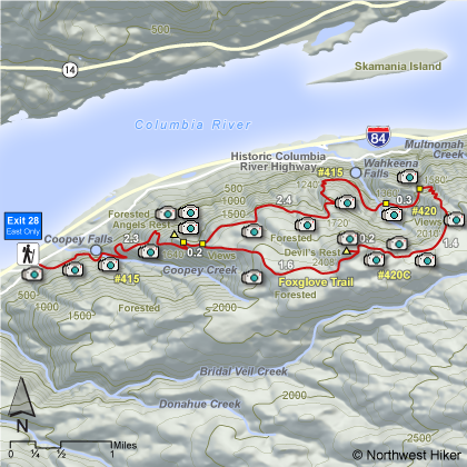
This hike begins at the Angels Rest trailhead and is relatively steep as it climbs through wooded areas and eventually out in the open near the summit of Angel's Rest where there are great vistas of the Columbia River Gorge and the surrounding mountains.

After passing the cutoff to Angel's Rest, bear right and follow the trail uphill to the next junction. At this point you can go either left or right because you will return to this junction after making a large loop. If you bare left and follow trail #415, you will eventually come to Wahkeena Springs junction.


Keep to the right and follow trail #420 to the Devil's Rest turnoff. Follow trail #420C up the hill and along the ridge to Devil's Rest. Enjoy the views along the trail, because after you reach Devil's Rest, you are in a heavily forested area with no views. Follow the Foxglove trail past Devil's Rest back to trail #415 near Angel's Rest. Return to the trailhead on the same trail to took to this junction. The Foxglove trail is less traveled and less maintained.


The following images are random samples of the wildflowers found in the Columbia River Gorge National Scenic Area.
Mouseover image to view flower name, and click on image to jump to flower guide.

Directions:

From Portland, OR
From Portland, travel east on Interstate Hwy 84 to Exit


Click on the link below to see a map taking you to the trailhead.

Map Directions


Vicinity Map


To contact the Columbia River Gorge National Scenic Area for current information: Click Here.


A Virtual Hike in the Columbia River Gorge National Scenic Area
Click for PDF
Click for PDF
Click for larger image Click for larger image Click for larger image Click for larger image Click for larger image Click for larger image Click for larger image Click for larger image Click for larger image Click for larger image Click for larger image Click for larger image Click for larger image Click for larger image Click for larger image Click for larger image Click for larger image Click for larger image