Summary:
Press CTRL + P to print. Photos do not show when you print this page. (Help)

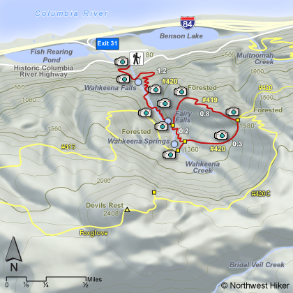
This hike begins at the Wahkeena Falls trailhead and is a
moderate climb to base of falls. There is a stone bridge
that crossed Wahkeena Creek directly in front of Wahkeena
Falls and you are likely to get spray from the falls in
almost any season.
Then this paved trail climbs steeply through a number
of switchbacks to Lemmons Overlook of the Columbia River Gorge.
The trail then continues unpaved up a steep grade, crossing
Wahkeena Creek two times. The second bridge was destroyed
by a fallen tree a couples of years ago, so the second
crossing may be challenging.
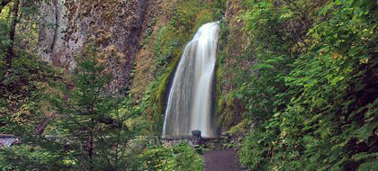
 Shortly after this and a few more switchbacks later, you
will come to Fairy Falls. This falls is one of the most
photogenic falls in the gorge. A small bridge crosses
the creek that forms this falls directly in front of it.
Shortly after this and a few more switchbacks later, you
will come to Fairy Falls. This falls is one of the most
photogenic falls in the gorge. A small bridge crosses
the creek that forms this falls directly in front of it.
The trail continues to climb through even more switchbacks.
Soon you will come to a junction that allows you the option
of completing your hike clockwise or counterclockwise. Your choice.
If you bear to the right, you will continue up several switchbacks
and soon come to another junction. This is the junction to Trail #415,
which leads west to Angels Rest. If you follow this trail just a
short distance, you will come to Wahkeena Springs. The entire
Wahkeena Creek literally erupts right out of the ground in one
giagantic springs.... thus, Wahkeena Springs.
 Retracing your steps back to the last junction, you can simply
return to your vehicle back baring left and follow the trail which
brought you to this point, or you can bare right and continue to
climb to the junction to Devils Rest.
Retracing your steps back to the last junction, you can simply
return to your vehicle back baring left and follow the trail which
brought you to this point, or you can bare right and continue to
climb to the junction to Devils Rest.
If you bare right and go on to the Devils Rest junction, you will
arrive at an junction, which by baring left, you will come back
to the Wahkeena Trail at the junction that you passed earlier while
climbing to the junction to Wahkeena Springs. This option will
take you back to the trailhead where you began.
Note, to continue on Trail #420, you could eventually come to
Multnomah Falls. But this is another hike.
|
|