THE FOLLOWING MAPS ARE NOT TO BE USED FOR NAVIGATIONAL PURPOSES.
View the slideshow for more sequential photos of this hike.
Length: 4.8 miles round trip Elevation Change: Climb 1540' before
descending back to the trailhead. Season: Year Round Difficulty: Challenging due to steepness of the trail Permit: No Pass Required Features:
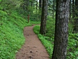
This hike can be done clockwise or counterclockwise. This description
will be clockwise. The paved trail takes the hiker across the bridge between the
lower and upper Multnomah Falls, then continues steeply through mostly wooded
areas with occasional views and many switchbacks to the top of the
ridge. The trail continues downhill for a short distance then after the
turnoff to the view point at the top of Multnomah Falls, the trail becomes
unpaved.
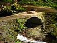
There is a large stone bridge across Multnomah Creek, then the
trail begins to climb again but not as steep. After crossing the bridge
there is a junction to the right to the Perdition Trail which has been closed
for several years due to unsafe conditions. Continue up Trail #441 pass many
outstanding waterfalls for about .8 miles and turn right at the junction to Trail #420.
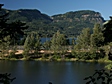
This trail continues uphill for another .8 miles then intersects an optional way down to Wahkeena Falls
by Trail #419. Or one can continue on Trail #420 which takes the hiker past
the trail to Angel's Rest and continues downhill past Fairy Falls to Wahkeena Falls.
There is a short half mile hike back to Multnomah Falls that parallels the Old
Columbia River Highway.
The following images are random samples of the wildflowers found in the Columbia River Gorge National Scenic Area.
Mouseover image to view flower name, and click on image to jump to flower guide.


 View the slideshow for more sequential photos of this hike.


 There is a large stone bridge across Multnomah Creek, then the
trail begins to climb again but not as steep. After crossing the bridge
there is a junction to the right to the Perdition Trail which has been closed
for several years due to unsafe conditions. Continue up Trail #441 pass many
outstanding waterfalls for about .8 miles and turn right at the junction to Trail #420.
There is a large stone bridge across Multnomah Creek, then the
trail begins to climb again but not as steep. After crossing the bridge
there is a junction to the right to the Perdition Trail which has been closed
for several years due to unsafe conditions. Continue up Trail #441 pass many
outstanding waterfalls for about .8 miles and turn right at the junction to Trail #420.
 This trail continues uphill for another .8 miles then intersects an optional way down to Wahkeena Falls
by Trail #419. Or one can continue on Trail #420 which takes the hiker past
the trail to Angel's Rest and continues downhill past Fairy Falls to Wahkeena Falls.
This trail continues uphill for another .8 miles then intersects an optional way down to Wahkeena Falls
by Trail #419. Or one can continue on Trail #420 which takes the hiker past
the trail to Angel's Rest and continues downhill past Fairy Falls to Wahkeena Falls.
 There is a short half mile hike back to Multnomah Falls that parallels the Old
Columbia River Highway.
There is a short half mile hike back to Multnomah Falls that parallels the Old
Columbia River Highway.


