| Hike 14 |
Multnomah Falls, Multnomah Creek, Sherrard Point, Larch Mt Loop |
Main Menu |


|
THE FOLLOWING MAPS ARE NOT TO BE USED FOR NAVIGATIONAL PURPOSES.
 View the slideshow for more sequential photos of this hike.
|
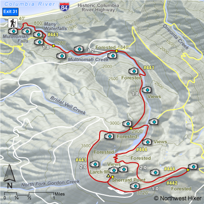
Length: 15.8 miles round trip
Elevation Change: 4016' gain
Season: Late Spring thru early Fall
Difficulty: Very Difficult due to steepness of trail and length of hike
Permit: Not Required at Multnomah Falls TH
Features: 
The name of the trail that leads to the top of Multnomah Falls
is called the Larch Mountain Trail #441. This is because if you follow
this trail to its end, you will be on top of Larch Mountain.
It is after about a mile of steep climbing that you find the
cutoff trail to the top of Multnomah Falls, but if you did not
turn there, but kept on straight ahead, eventually you would
arrive at Larch Mountain.
 After you pass the cutoff to the top of Multnomah Falls, the
trail simply follows Multnomah Creek for the next several miles.
At about 1.8 miles into this hike, you pass the trail that takes you west to Wahkeena
Falls. And at about three miles you pass the trail that takes
you to Franklin Ridge. However to reach Larch Mountain you keep
staight ahead.
After you pass the cutoff to the top of Multnomah Falls, the
trail simply follows Multnomah Creek for the next several miles.
At about 1.8 miles into this hike, you pass the trail that takes you west to Wahkeena
Falls. And at about three miles you pass the trail that takes
you to Franklin Ridge. However to reach Larch Mountain you keep
staight ahead.
 At 4.8 miles you come to a junction that allows you to make
a loop out of this hike. It is a bit further, but it adds more
diversity and adventure to the hike. You can continue straight
ahead on Trail #441 to the top of Larch Mountain, or you can
bear left on Trail #444. This trail will bring you to the
meadow at the base of Sherrard Point, which is the 4056' summit of
Larch Mountain.
At 4.8 miles you come to a junction that allows you to make
a loop out of this hike. It is a bit further, but it adds more
diversity and adventure to the hike. You can continue straight
ahead on Trail #441 to the top of Larch Mountain, or you can
bear left on Trail #444. This trail will bring you to the
meadow at the base of Sherrard Point, which is the 4056' summit of
Larch Mountain.
 Trail #444 takes you past the meadow to a ridge on the eastern
flank of Larch Mountain. There you bear right on Trail #
which takes you to a paved road which leads to a parking
area near the summit of the mountain. The Larch Mountain
Trail, which will lead you back to Multnomah Falls is clearly
marked at the northwestern end of the parking area.
Trail #444 takes you past the meadow to a ridge on the eastern
flank of Larch Mountain. There you bear right on Trail #
which takes you to a paved road which leads to a parking
area near the summit of the mountain. The Larch Mountain
Trail, which will lead you back to Multnomah Falls is clearly
marked at the northwestern end of the parking area.
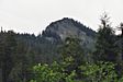
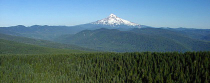
 Having made it this far, you most certainly will want to
walk the quarter mile to Sherrard Point, which is the
actual summit of Larch Mountain. Here you are treated
to magnificent views of the surround mountains; Mt. St. Helens,
Mt. Rainier, Mt. Adams, Mt. Hood, and Mt. Jefferson.
Having made it this far, you most certainly will want to
walk the quarter mile to Sherrard Point, which is the
actual summit of Larch Mountain. Here you are treated
to magnificent views of the surround mountains; Mt. St. Helens,
Mt. Rainier, Mt. Adams, Mt. Hood, and Mt. Jefferson.
After your refreshing break and photo op, return to the
parking area, and find the Larch Mountain Trail which
you can now desend to your vehicle which is about 7 miles
ahead of you and an elevation loss of over 4000 feet. Hope you have good brakes.
|
|
|
The following images are random samples of the wildflowers found in the Columbia River Gorge National Scenic Area.
Mouseover image to view flower name, and click on image to jump to flower guide.
|
Directions:
From Portland, OR
From Portland, travel east on Interstate Hwy 84 to Exit
Click on the link below to see a map taking you to the trailhead.
|
|
|
|
 |


