THE FOLLOWING MAPS ARE NOT TO BE USED FOR NAVIGATIONAL PURPOSES.
View the slideshow for more sequential photos of this hike.
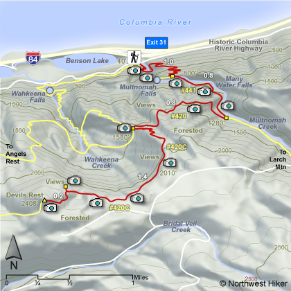
Length: 8.4 miles round trip Elevation Change: 2368' Season: Spring thru Fall Difficulty: Challenging due to steepness of trail and length of hike Permit: No Pass Required Features:
This hike is an alternate route to Devils Rest. It begins on the
east side of Multnomah Falls Lodge and is the same trail at first
that one takes to climb to the top of Multnomah Falls, or for that
matter to do what is called the Multnomah-Wahkeena Loop Hike.
This paved trail takes the hiker across the bridge between the
lower and upper falls, then continues steeply through mostly wooded
areas with occasional views and many switchbacks to the top of the
ridge. The trail continues downhill for a short distance then after the
turnoff to the view point at the top of Multnomah Falls, the trail becomes
unpaved.
There is a large stone bridge across Multnomah Creek, then the
trail begins to climb again but not as steep. After crossing the bridge
there is a junction to the right to the Perdition Trail which has been closed
for several years due to unsafe conditions. Continue up Trail #441 for about
.8 miles and turn right at the junction to Trail #420. This trail continues
uphill for another .8 miles to the junction to Devilrest's Rest and Trail #420C.
Make the sharp left turn onto Trail #420C which then climbs steeply through
several switchbacks before leveling off for the next mile. There are several
good views along this part of the hike. The last .2 miles of the hike is in
a dense wooded area and there is no view at the summit. So, when you have
the opportunity, take one of the many short user trails to the edge of the
cliff you are following for great views of the gorge and the mountains to
the north.
The following images are random samples of the wildflowers found in the Columbia River Gorge National Scenic Area.
Mouseover image to view flower name, and click on image to jump to flower guide.


 View the slideshow for more sequential photos of this hike.


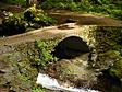 There is a large stone bridge across Multnomah Creek, then the
trail begins to climb again but not as steep. After crossing the bridge
there is a junction to the right to the Perdition Trail which has been closed
for several years due to unsafe conditions. Continue up Trail #441 for about
.8 miles and turn right at the junction to Trail #420. This trail continues
uphill for another .8 miles to the junction to Devilrest's Rest and Trail #420C.
There is a large stone bridge across Multnomah Creek, then the
trail begins to climb again but not as steep. After crossing the bridge
there is a junction to the right to the Perdition Trail which has been closed
for several years due to unsafe conditions. Continue up Trail #441 for about
.8 miles and turn right at the junction to Trail #420. This trail continues
uphill for another .8 miles to the junction to Devilrest's Rest and Trail #420C.


