


|
THE FOLLOWING MAPS ARE NOT TO BE USED FOR NAVIGATIONAL PURPOSES.
 View the slideshow for more sequential photos of this hike.
|
Length: 2.6 mile round trip
Elevation Change: 860' gain
Season: Summer thru Fall
Difficulty: Moderate
Permit: No Pass Required
Features: 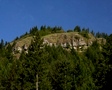
The trailhead for this hike is very much in question. I have
illustrated my preference on the above map, but it is not necessarily the legitimate one.
You must stay on the access road when you approach the
trailhead for this hike as you are crossing private property and could be
accused of trespassing.
 The trail is actually an old road that was used during world war two to take supplies
to a facility atop Aldrich Butte that was used to protect Bonneville Dam. Therefore
the grade is rather gentle, even though the road is rutted from water runoff. After
you enter the timbered area of the hike, you are surrounded by Forest Service land, but
nevertheless, it would be wise to stay on the trail/road. In about a mile you will
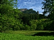
come to an opening. There is a lake (pond) in this area known as Carpenter Lake. This
also provides a great view of Table Mountain.
The trail is actually an old road that was used during world war two to take supplies
to a facility atop Aldrich Butte that was used to protect Bonneville Dam. Therefore
the grade is rather gentle, even though the road is rutted from water runoff. After
you enter the timbered area of the hike, you are surrounded by Forest Service land, but
nevertheless, it would be wise to stay on the trail/road. In about a mile you will
come to an opening. There is a lake (pond) in this area known as Carpenter Lake. This
also provides a great view of Table Mountain.
 The trail to the top of Aldrich Butte follows an old road bed that took visitors to the
top via motor vehicle. Even today there are those who ride to the summit on 2, 3, and
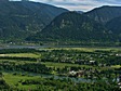
4 wheelers. Nevertheless, the hike is fine and definitely worth the effort. The views
from the top are great and a fine reward. When you near the summit, you will have views
in almost all directions. Depending on the time of day you arrive, some views are better
than others. I personally prefer that afternoon lighting.
The trail to the top of Aldrich Butte follows an old road bed that took visitors to the
top via motor vehicle. Even today there are those who ride to the summit on 2, 3, and
4 wheelers. Nevertheless, the hike is fine and definitely worth the effort. The views
from the top are great and a fine reward. When you near the summit, you will have views
in almost all directions. Depending on the time of day you arrive, some views are better
than others. I personally prefer that afternoon lighting.
|
|
The following images are random samples of the wildflowers found in the Columbia River Gorge National Scenic Area.
Mouseover image to view flower name, and click on image to jump to flower guide.
|
Directions:
From Portland, OR
From Portland, travel east on Interstate Hwy 84 to Exit
Click on the link below to see a map taking you to the trailhead.
|
|
|
|
 |


