THE FOLLOWING MAPS ARE NOT TO BE USED FOR NAVIGATIONAL PURPOSES.
View the slideshow for more sequential photos of this hike.
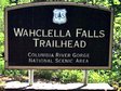
Length: 2.0 miles round trip Elevation Change: 300' gain Season: Year Round Difficulty: Easy Permit: NW Forest Pass Required Features:
Another gem of gems! This hike is terrific, and so very easy. Start
at the Wahclella trailhead parking lot and walk along a service road parallel to Tanner
Creek for about a quarter mile. In the fall you can see the salmon in this stream. As you continue on your
hike, you will gently begin to climb.
A word of caution that applies to all the trailhead parking areas. Be sure to leave nothing
of value in your vehicle. Theives frequent these places. I actually leave my doors unlocked
and leave nothing of value in my jeep. I have had my vehicles broken into a number of times.
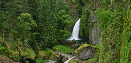
In about a 1/2 mile you will come to a junction where the trail loops, using two excellent
bridges to provide you the opportunity to view the falls and canyon from both sides of
Tanner Creek. If you bear left, after about 3/4 miles you will begin to descend right
to the base of Wahclella Falls. You can continue across a bridge to gain
additional views of this wonderful waterfall and the little gorge that it is in.
You will then cross that 2nd bridge and the trail will loop back to the junction
that you passed earlier.
The following images are random samples of the wildflowers found in the Columbia River Gorge National Scenic Area.
Mouseover image to view flower name, and click on image to jump to flower guide.


 View the slideshow for more sequential photos of this hike.