


|
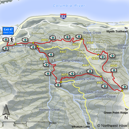
THE FOLLOWING MAPS ARE NOT TO BE USED FOR NAVIGATIONAL PURPOSES.
 View the slideshow for more sequential photos of this hike.
|
Length: 14 miles RT
Elevation Change: - 4400' cummulative gain
Season: - Late spring thru early fall
Difficulty: Very Difficult due to length of hike and elevation gained
Permit: NW Forest Pass Required
Features: 
This hike begins at the Herman Creek trailhead. Often you have to
park on the frontage road if you try to hike from this trailhead before the Herman Creek
campground is open. You will come to a junction that leads to the PCT and Benson Ridge,
but bear left and follow the signs to Gorton Creek trail. At about 1.2 miles you will
begin a more serious climb to an overlook of Indian Point. Continue your hike following
Trail #408 a brief distance to the junction of Trail #408 and cutoff Trail #437. Stay
on Trail #408. You loose some elevation over the next half mile before coming to the
junction of Trail #408 and Trail #422. Continue on #408 and soon you will come to
Deadwood Camp.
 This appears to be a roomy and clean camp area. Water is a short distance
before you reach the camp. After the camp, the trail begins to climb through a series
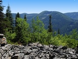
of a half dozen switchbacks. At the end of this rise, you get your first glimpse out of
the forested area.
This appears to be a roomy and clean camp area. Water is a short distance
before you reach the camp. After the camp, the trail begins to climb through a series
of a half dozen switchbacks. At the end of this rise, you get your first glimpse out of
the forested area.
Wildflowers are common in season. The trail continues to climb and
is not in good condition. Eventually, you come to a rocky open area which affords the
hiker great views to the north and northeast. After hiking through the thick forest for
a short distance, you come to another, larger rocky area, again with some great views.
When you finally reach the junction of Trail #408 and Trail #447, you are most likely
grateful to have this hike half over. Follow Trail #447 northwest toward the junction
of the Casey Creek Cutoff Trail #476.
 This stretch of trail is very poorly maintained.
There are occasional views along this part of the hike, but nothing spectacular. When
you reach Trail #476, follow it down the mountain to the Herman Creek Trail #406. This
is a VERY STEEP trail, use caution. Upon reaching Trail #406, turn right and follow it
north past several streams and falls to the junction of Trail #408 and #406 where you
began the loop portion of the hike. Just retrace your steps at this point back to the
Herman Creek trailhead and the wonderful comfort of your vehicle.
This stretch of trail is very poorly maintained.
There are occasional views along this part of the hike, but nothing spectacular. When
you reach Trail #476, follow it down the mountain to the Herman Creek Trail #406. This
is a VERY STEEP trail, use caution. Upon reaching Trail #406, turn right and follow it
north past several streams and falls to the junction of Trail #408 and #406 where you
began the loop portion of the hike. Just retrace your steps at this point back to the
Herman Creek trailhead and the wonderful comfort of your vehicle.
|
|
The following images are random samples of the wildflowers found in the Columbia River Gorge National Scenic Area.
Mouseover image to view flower name, and click on image to jump to flower guide.
|
Directions:
From Portland, OR
From Portland, travel east on Interstate Hwy 84 to Exit
Click on the link below to see a map taking you to the trailhead.
|
|
|
|
 |


