


|
THE FOLLOWING MAPS ARE NOT TO BE USED FOR NAVIGATIONAL PURPOSES.
 View the slideshow for more sequential photos of this hike.
|
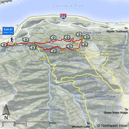
Length: 7 miles RT
Elevation Change: - 2700' gain
Season: - Spring thru late fall
Difficulty: Difficult
Permit: NW Forest Pass Required
Features: 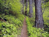
This is a very popular and worthy hike. It begins at the Herman Creek
trailhead. Often you have to park on the frontage road if you try to
hike from this trailhead before the Herman Creek
campground is open. The trail drops a bit at first, but immediately climbs up
and under high power lines then into a forested area. In about a half
mile the trail junctions with a trail to Herman Creek and the PCT. Bear
left and in just a short distance you will be hiking on an old abandoned
road. The trail follows the road for another half mile when on your
left you will see an open area with the junction of two other trails.
The trail on the far left is Gorge Trail #400. The trail in the center
of the clearing is the Gordon Creek Trail #408. You will follow this trail
to the Indian Point overlook. The trail gradually gets steeper and steeper.
This entire hike is almost completely within a densely forested area.
The trail is in excellent repair and has ample swithbacks that keep the
hike from becoming too steep.
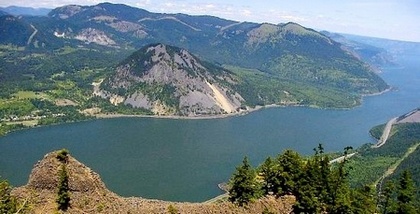
At about three and a half miles you will come to an extremely sharp
switchback to the right. It is at this turn in the trail where you
should see before you, a user trail leading through the trees to
an outstanding overlook of not only Indian Point, but of the Columbia
River Gorge, Dog Mountain, Augspurger Mountain, Wind Mountain, and
Mt. Adams.
There is a unmaintained trail out onto the point, but use EXTREME CAUTION if you are tempted to
hike out there. Northwest Hiker does NOT promote this option.
I recommend making a loop out of this hike by taking the cutoff Trail #437 to Trail #447, which
is your elevator back to the bottom where you began. This return trail #447 is very very
steep. Actually, if you desire pain and suffering, you could do this hike in reverse, and
climb up trail #447. If you survive, then take trail #437 over to trail #408 and the
Indian Point overlook. Then return to the trailhead via trail #408.
|
|
|
The following images are random samples of the wildflowers found in the Columbia River Gorge National Scenic Area.
Mouseover image to view flower name, and click on image to jump to flower guide.
|
Directions:
From Portland, OR
From Portland, travel east on Interstate Hwy 84 to Exit
Click on the link below to see a map taking you to the trailhead.
|
|
|
|
 |


