THE FOLLOWING MAPS ARE NOT TO BE USED FOR NAVIGATIONAL PURPOSES.
View the slideshow for more sequential photos of this hike.
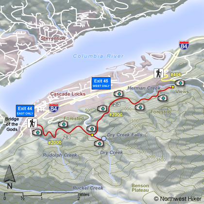
Length: 8.6 miles RT Elevation Change: 750' gain Season: Year Round except during ice/snow storms Difficulty: Moderate due to length of hike Permit: NW Forest Pass Required Features:
This hike is presented as not only the hike to Dry Creek Falls, but it is
designed to show you what to expect between Cascade Locks and the Herman
Creek Trail. The hike begins at the trailhead right next to the Bridge
of the Gods in Cascade Locks. This excellent trailhead has a nice restroom
facility. Keep in mind that this trail is the Pacific Crest Trail (PCT).
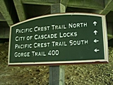
The trail begins by working its way through the community of
Cascades Locks without seeming like it is in a developed area. There
are plenty of signs giving direction to you as your follow the PCT.
This hike is relatively easy and stays mostly in the valley paralleling the
interstate freeway for about 4 miles. Although most of the time you do not hike close
enough to hear the traffic.
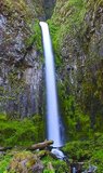
After about two miles the trail will come to Dry Creek. You will be on an old
roadbed which if you follow it to the right, will lead you to Dry Creek Falls.
If you desire to hike on to the Herman Creek trail, then cross Dry Creek on the
bridge and head east. In about a mile and a quarter you will come upon some
interesting looking rock pillars. This is a great place to relax and explore
before continuing on your adventure. At about another quarter mile or so you
will come to a waterfall. This falls varies in volume and beauty, depending
on what time of year you are there.
It is about another mile to the junction with the Herman Creek trail. One could
do a shuttle hike, if you arranged a vehicle at the Herman Creek trailhead. You
could just follow the Herman Creek trail down to the trailhead.
The following images are random samples of the wildflowers found in the Columbia River Gorge National Scenic Area.
Mouseover image to view flower name, and click on image to jump to flower guide.


 View the slideshow for more sequential photos of this hike.


 After about two miles the trail will come to Dry Creek. You will be on an old
roadbed which if you follow it to the right, will lead you to Dry Creek Falls.
If you desire to hike on to the Herman Creek trail, then cross Dry Creek on the
bridge and head east. In about a mile and a quarter you will come upon some
interesting looking rock pillars. This is a great place to relax and explore
before continuing on your adventure. At about another quarter mile or so you
will come to a waterfall. This falls varies in volume and beauty, depending
on what time of year you are there.
After about two miles the trail will come to Dry Creek. You will be on an old
roadbed which if you follow it to the right, will lead you to Dry Creek Falls.
If you desire to hike on to the Herman Creek trail, then cross Dry Creek on the
bridge and head east. In about a mile and a quarter you will come upon some
interesting looking rock pillars. This is a great place to relax and explore
before continuing on your adventure. At about another quarter mile or so you
will come to a waterfall. This falls varies in volume and beauty, depending
on what time of year you are there.


