


|
THE FOLLOWING MAPS ARE NOT TO BE USED FOR NAVIGATIONAL PURPOSES.
 View the slideshow for more sequential photos of this hike.
|
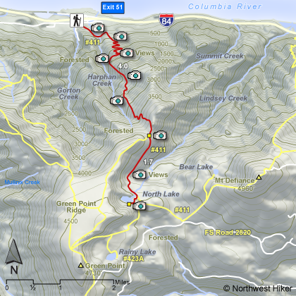
Length: 11.4 miles round trip
Elevation Change: 4240' cummulative gain
Season: Midsummer
thru Fall
Difficulty: Very Difficult due to steepness of trail and length of hike
Permit: NW Forest Pass Required
Features: 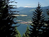
Here is a really challenging hike. North Lake is a worthy destination
and the climb to enjoy it is, well, challenging. The Wyeth trail to
North Lake climbs at one of the steepest inclines in the gorge. The
trailhead is located at the south end of the Wyeth campground off I84
and exit 51. The trail begins rather gently to give you a false sense
of ease, but beware. You will cross a small stream, which can be a
bit challenging if the water is high.
After you cross the stream, the trail gets a bit steeper, but in a short
distance it comes to a major switchback and then watch out! Did I mention
this hike is challenging? Well, I suppose I did, but you might find it
even more than challenging. Actually, as is indicated above, I label
this hike very difficult. Anytime you climb a 1000 feet per mile, for
four miles, well, in my book, that's very difficult.
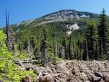 The climb up the Wyeth Trail offers a few excellent vistas of the Columbia River
gorge. After four miles the trail comes to the junction of the Green Point
Trail. Bear left and keep on toward North Lake. In another quarter mile
you will come out into an opening where you get a great view of Mt. Defiance
to the east. Shortly after that the trail goes through a wet swampy area
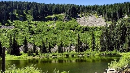
before climbing up to the lake. North Lake is a shallow little lake surrounded by forests and the
cliffs of Green Point Ridge.
The climb up the Wyeth Trail offers a few excellent vistas of the Columbia River
gorge. After four miles the trail comes to the junction of the Green Point
Trail. Bear left and keep on toward North Lake. In another quarter mile
you will come out into an opening where you get a great view of Mt. Defiance
to the east. Shortly after that the trail goes through a wet swampy area
before climbing up to the lake. North Lake is a shallow little lake surrounded by forests and the
cliffs of Green Point Ridge.
|
|
|
The following images are random samples of the wildflowers found in the Columbia River Gorge National Scenic Area.
Mouseover image to view flower name, and click on image to jump to flower guide.
|
Directions:
From Portland, OR
From Portland, travel east on Interstate Hwy 84 to Exit
Click on the link below to see a map taking you to the trailhead.
|
|
|
|
 |


